01.08.11
Posted in Weather Forecast, Weather News, Winter Weather at 8:00 am by Rebekah
Weather Discussion

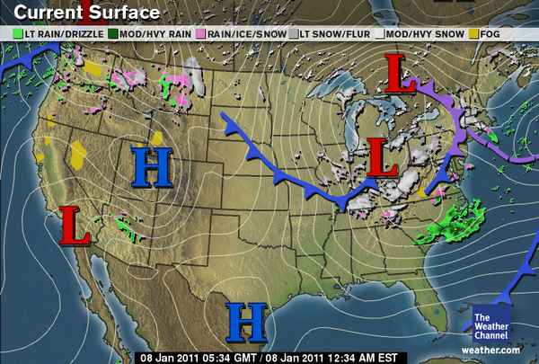
National: The primary features on satellite and upper-air maps are the large low-pressure system over the Northeast and the split-flow over the West, including a shortwave trough over the Northwest, a ridge over the northern Rockies, and a shortwave trough over the Southwest.
Rain and snow is ongoing in the Cascades and northern Rockies, a large surface high is located over the Great Basin, and the mature cyclone over the Northeast is bringing snow to New England and the Ohio River Valley. An arctic front extending across the central part of the country is bringing cold temperatures to the Plains as well as a chance for freezing rain and snow.
Southern Plains: The shortwave trough over the Southwest will dip down into Texas on Sunday, increasing lift and the chances for rain and snow in the wake of the cold front. Ground temperatures will probably be too warm for much snow accumulation; the greatest chance for snow would be in eastern Oklahoma, where temperatures are expected to be colder.
The type of precipitation is rather tricky to forecast for Oklahoma…forecast soundings for central Oklahoma Sunday evening show a saturated profile just at or below freezing. This means snow could fall, but if the temperature winds up just a little warmer than forecast, we could get just rain or even freezing rain. On the other hand, it looks a bit more certain that a snow/sleet event is building for the Arklatex region on Sunday and sleet/freezing rain for the Southeast on Monday and Tuesday.
On Monday, a trough will deepen over the Rockies and the exit region of a jet streak will be over Oklahoma. This will enhance lift and there will be another chance for some wintry precipitation. Forecast soundings for central Oklahoma again show saturated profiles just below freezing. Northern Oklahoma may get a bit more snow on this day.
The cooler weather will continue throughout the week…high temperatures in Oklahoma will primarily be in the 30s, with lows in the 20s. The latter half of the week should remain dry but breezy.
Permalink
01.07.11
Posted in Winter Weather at 8:00 am by Rebekah
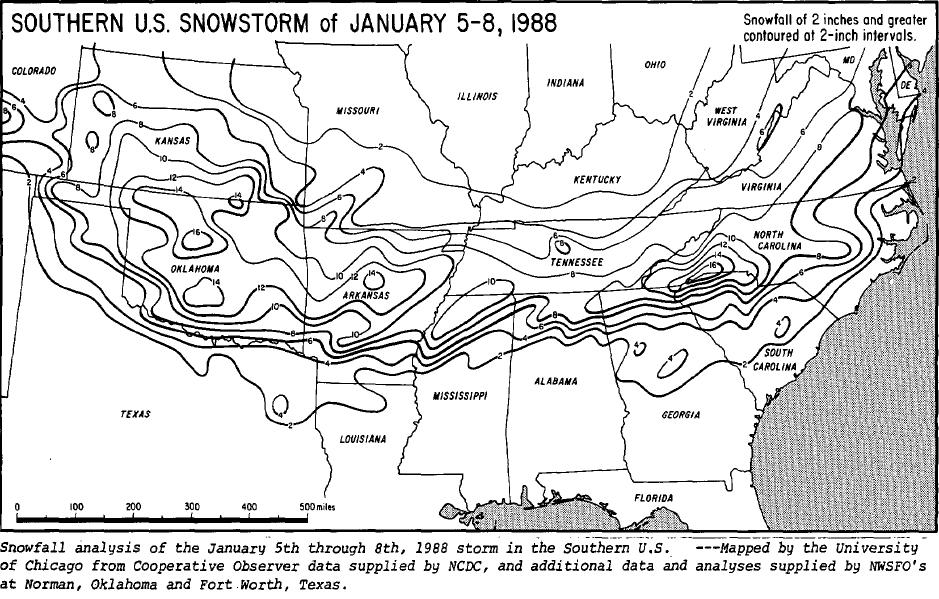
From January 5 – 8, 1988, a winter storm dumped over a foot of snow and sleet across the southern United States. Over 3 million chickens were killed in Alabama, Georgia, and Texas, following the collapse of dozens of poultry houses due to the weight of snow and ice.

Snowfall totals from the Rockies to the mid-Atlantic coast. Most states affected received at least 8 inches of snow. Far northwestern South Carolina reported an unofficial snowfall total of 27 inches. Courtesy of NCDC/Storm Data. Click to enlarge.
Timeline
- Monday, January 4th: A cold front associated with a deep trough over the central and eastern U.S. brought well-below-average, sub-freezing temperatures deep into the Southeast
- Wednesday, January 6th: A new shortwave trough developed and tracked over the Southern Plains, inducing the formation of a weak surface low just off the Texas Coast…snow was already falling in Oklahoma, and began to fall in far northern Mississippi and Alabama and southern Tennessee
- Thursday, January 7th: The surface low set up near Mobile, Alabama, allowing slightly warmer air to advance northward…this resulted in precipitation changing to sleet and freezing rain…later in the evening, much of the precipitation turned back to snow
- Friday, January 8th: Snow tapered off in the Southeast, although strong winds continued to cause significant snow drifts…meanwhile, the surface low strengthened along the East Coast and brought snow to the mid-Atlantic states and New England
Aftermath
Sub-freezing temperatures continued even after the storm had passed, allowing snow and ice to remain on the ground for several days.
Many schools were closed for the week and roads were closed for days throughout much of the Tennessee River Valley. Many flights in the areas affected were delayed or canceled during the storm. Some power outages lasted for several days in the southern states more affected by the ice.
About 60 people died as a result of the snow and cold this week.
Governor Guy Hunt declared a state of emergency for northern Alabama, after about 2 million chickens were killed due to the collapse of their shelters, resulting in over $15 million of damage. Over half a million chickens also perished in eastern Texas, and another half a million died in northern Georgia.
Sources: NWS Huntsville January 1988 Winter Storm; Winter storm across the nation (Ocala Star-Banner); Dead chickens called public health threat (The Tuscaloosa News); Storm may boost poultry prices (The Dallas Morning News).
Permalink
01.06.11
Posted in Uncategorized at 8:00 am by Rebekah

Photo by Jeff Makowski.
Recently I was asked to do a few interviews on storm chasing (see one article here), and I had a reporter ask me, prior to meeting, “I know a lot of storm chasing equipment is big and heavy, but would you be able to bring something in to demonstrate?”
I offered to bring in my laptop, but thought what kind of heavy-duty equipment is she expecting?
While the image many people have of storm chasers may consist of a vehicle decked out with a weather station, lightbars, and stickers, the amount of equipment that different chasers have may actually run from none to infinite.
Before the days of cell phones and computers, a chaser’s only piece of equipment was his eyes (well, besides a car and perhaps a map). Chasers had to know how to read the sky by looking for certain clues.
Today, many, if not most, chasers chase with at least a GPS and wireless data via cell phones and laptops. Many chasers also use cameras and video cameras to record the chase, and some like to place stickers, lightbars, hail guards, and/or weather equipment on the outside of their vehicle.
The only required equipment for storm chasing, though, is a knowledge of the weather and how storms work.
While “techno” storm chasing might keep us safer, by allowing us to see the storm on radar and stay away from that large hail, there is also somewhat of a danger with this method, if we become too dependent on our technology. Chasing is not as simple as getting in a car and going to the nearest radar blob that you see on your iPhone. Well, at least it usually isn’t. You must properly educate yourself before chasing, so you know what to look for when (not if) your technology fails you, and so that you know what to do to stay safe.
You’ll be a more successful, safer, and less stressed out chaser if you learn how the weather works, so you know how to read the sky for clues rather than only know how to read a radar display.
Tim Vasquez’ “Storm Chasing Handbook” is one of the best books out there on describing what goes into storm chasing. I thoroughly read it before going storm chasing, and I highly recommend it!
Permalink
01.05.11
Posted in Weather - Miscellaneous at 8:00 am by Rebekah

How do you judge whether one place is rainier than another? Is it by the average annual rainfall? The average annual number of days where rain is falling?
Let’s take a look at a few places in Washington, one of the wettest states in the country (data from the WRCC):
- Forks (northwest Olympic Peninsula) – average precipitation days: 202 days; average precipitation: 121.73 inches
- Seattle (eastern edge of the Puget Sound) – average precipitation days: 155 days; average precipitation: 37.07 inches
- Vancouver (southwest Washington) – average precipitation days: 150 days; average precipitation: 41.92 inches
Based on these statistics, I think we’d have no trouble agreeing that Forks is rainier than both Seattle and Vancouver.
However, what about Seattle versus Vancouver? Vancouver receives more precipitation, but Seattle averages a few more rainy days per year.
One idea is that perhaps Seattle’s rains are of a lighter variety. Maybe Seattle gets more drizzle and Vancouver gets more moderate to heavy rains (hmm…maybe the type of rain could be another factor in deciding which of two places is rainier).
What do you think?
Permalink
01.04.11
Posted in Non-US Weather, Weather News at 8:01 am by Rebekah
This week’s post in the global weather and climate series features Rockhampton, Australia. Rockhampton is currently undergoing one of Australia’s worst flood events on record.

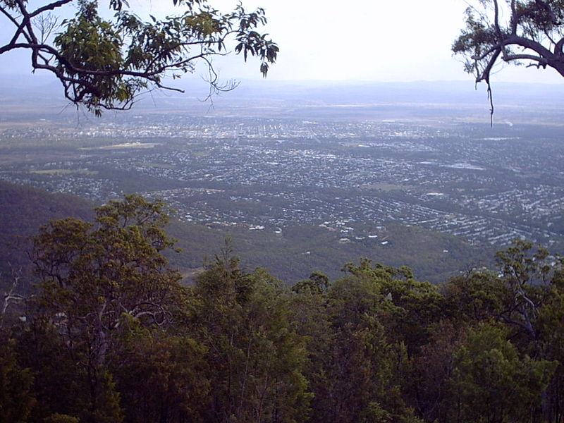
Rockhampton, from Mount Archer. Courtesy of Wikipedia.
Rockhampton is located in a hilly part of northeastern Australia, in the state of Queensland. Situated on the Fitzroy River, about 25 miles from the Coral Sea, Rockhampton lies just north of the Tropic of Capricorn.
Rockhampton was founded in the mid-1800s, as grazing lands and eventually gold attracted European settlers. Cattle continue to serve as a large part of the city’s economy, and Rockhampton promotes itself as the Beef Capital of Australia. The current population of the city is 76,729.

The Rockhampton Zoo features a Cassowary, naturally found only in New Guinea and far northeastern Queensland. A large, flightless bird, the Cassowary is smaller only than the ostrich and emu. Courtesy of Wikipedia.
A few more facts about Rockhampton (from Wikipedia):
- Time zone: Australian Eastern Standard Time (UTC+10)
- Average elevation: 37 feet (11.3 meters)
- Climate zone: Humid subtropical
- Average high temperature: 83 °F (28 °C)
- Average low temperature: 62 °F (17 °C)
- Average annual high/low temperature range: 74 to 90 °F (23 to 32 °C) / 49 to 72 °F (10 to 22 °C)
- Record high temperature: 114 °F (45 °C)
- Record low temperature: 30 °F (-1 °C)
- Average annual precipitation: 31 inches (799 mm)
Weather: Rockhampton is currently inundated, following copious amounts of rainfall during a tropical cyclone and various summer thunderstorms. The airport has been shut down (due to flooding) and only one escape route remains for the city. The water level in the Fitzroy River has reached 30 feet and is expected to go even higher by tomorrow, at which point the city should become completely isolated.
The area of Queensland that has been subject to the floods is greater than the size of Texas and greater than the size of France and Germany combined, with over 200,000 people being affected. Many people have had to leave their homes because the waters are too high. For more on the floods, see Sky News, BBC News, and MSNBC. Latest flood warning for the Fitzroy River.
Rockhampton experiences, on average, some 300 sunny days per year; however, there has been a trough of low-pressure situated over the Queensland coast for quite some time now, providing very rainy conditions. This setup is fairly common during La Niña years.
Unfortunately, as we are in a fairly strong La Niña, it does not look like Queensland will receive much relief from the rain any time soon. It may even take as long as a month before Queensland sees much relief from the rain and floodwaters.
For weather maps and information on current and forecast Rockhampton weather, see the Australian Bureau of Meteorology, Weatherzone, Weather Underground, and Weather Online UK.
For more information on Rockhampton, here’s a link to Wikipedia.
Next Tuesday I plan to take a look at the climate and weather in another part of the globe. As always, if you have any suggestions for future cities, please leave a comment!
Permalink
« Previous Page — « Previous entries « Previous Page · Next Page » Next entries » — Next Page »


