03.30.10
Posted in Non-US Weather, Weather News at 9:48 am by Rebekah
Last Tuesday I started a series of posts on global weather, focusing on current weather and climate of places around the world. The inaugural post took a look at Perth, Australia.
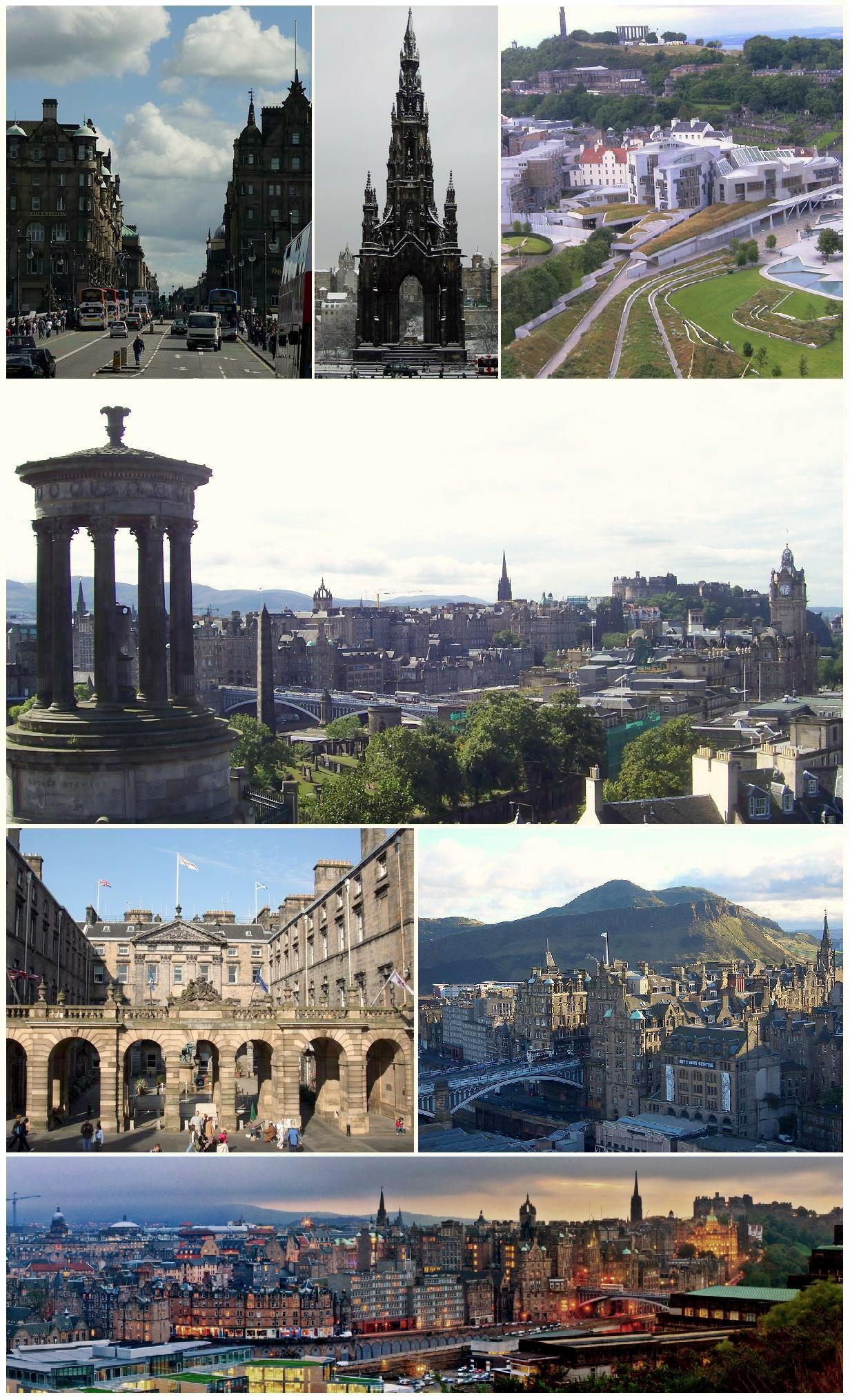
This week’s featured city is Edinburgh, Scotland, in the United Kingdom.

Edinburgh, Scotland. Courtesy of Wikipedia.
Situated in southeast Scotland, near the North Sea, Edinburgh is home to nearly 500,000 people (about 1.2 million in the metro). Edinburgh is the capital of Scotland and the second most popular tourist destination in the UK, behind London. A few facts about Edinburgh (climate data from Weatherbase):
- Time zone: Greenwich Mean Time (UTC+0) or British Summer Time (UTC+1)
- Elevation: ~135 ft above mean sea level
- Climate zone: Maritime (warm/moist summers, cool/wet winters)
- Average high temperature: 53 °F (11 °C)
- Average low temperature: 41 °F (5 °C)
- Record high temperature: 88 °F (31 °C)
- Record low temperature: 1 °F (-17 °C)
- Average annual precipitation: 26 inches (663 mm)
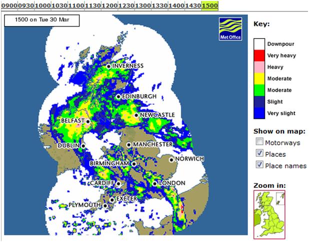
Current weather: This afternoon it is raining in Edinburgh, with a temperature of 38 °F (3.2 °C) as of 3pm local time. The pressure is 987 mb and falling. Not far north of the city it is snowing, and as cold air surges southward, the snow is expected to be heavy over parts of Scotland and Ireland.
The following shows a radar image (from the UK Met Office) at 3pm local time:

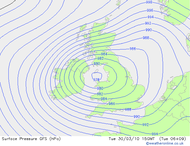
This rain and snow is associated with an extratropical cyclone that is making landfall on the Irish and British coasts. I can’t find any very good current surface maps of the UK, but here’s a 9-hr model run (initialized at 06Z and valid at 15Z, or 3pm local time), showing surface pressure contours (from Weather Online UK).

There is a pretty tight pressure gradient with this storm system, so not only will it bring sub-freezing temperatures to Scotland, but it will bring strong winds (roughly 35 mph in Scotland, 40 to 50 mph in western Scotland and northern Ireland, with gusts to 82 mph) that will blow the snow around and cause blizzard conditions in much of the country.
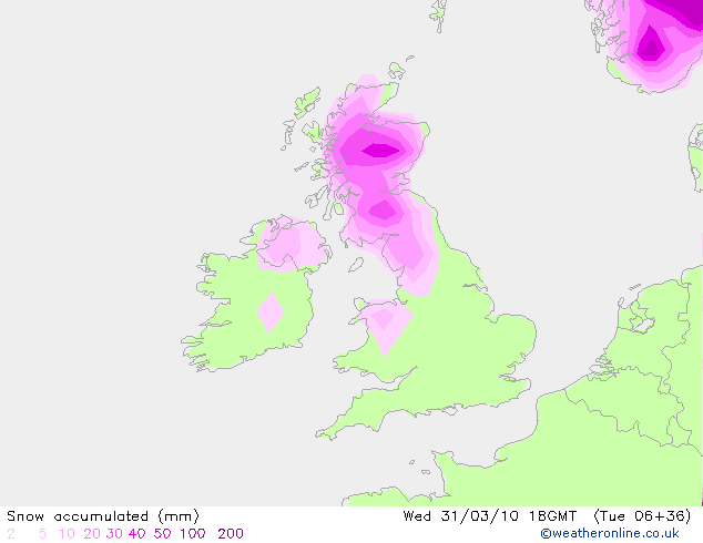
The UK Met Office (equivalent of the NWS in the US) is forecasting for 40 cm (about 16 inches) of snow or more in the Highlands of Scotland through Wednesday. The prediction of snow and gale-force winds prompted the UK Met Office to issue an early weather warning on Sunday, for heavy snow and blizzards over much of Scotland (and northern Ireland). That warning was updated today to an emergency weather warning for severe blizzards, severe drifting snow, and very heavy snowfall. Obviously, Edinburgh, sitting on the coast, won’t receive as much snow, but the city may still get a few inches that will get blown around in the winds.
Here’s the GFS model (from Weather Online UK) of 6-hr snow accumulation, ending after the heaviest snow through 18Z (7pm local time) on Wednesday. This map shows a max of 40 – 50 mm of snow over the Highlands from 12Z to 18Z Wednesday.

For more information on Edinburgh, here’s a link to Wikipedia.
For more information on the ongoing blizzard, here’s the BBC weather news page.
For weather maps and information on Edinburgh weather, including the latest weather warnings, see the UK Met Office or Weather Online UK (great collection of weather maps and models for all over the world).
Next Tuesday I’ll take a look at the climate and weather in another part of the globe. As always, if you have any comments or suggestions for future cities, please leave a comment!
Permalink
03.28.10
Posted in Weather News at 3:14 pm by Rebekah
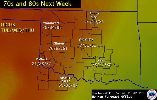
Warm, south winds and mostly sunny skies? Temperatures in the 70s and 80s? What is this strange weather?
It appears as if spring has finally arrived.
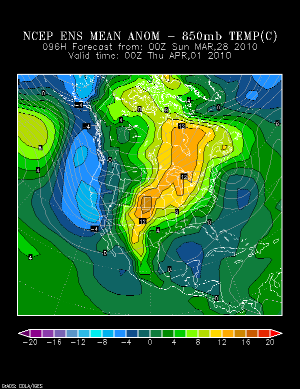
Take a look at the map below, from the NOAA Earth System Research Laboratory. This is a model forecast of 850mb (low-level atmosphere) temperature anomalies for 00Z on Thursday, or 7pm Central Time on Wednesday. Wednesday is probably going to be the warmest day of the week for central Oklahoma (unfortunately, for those of you on the West Coast, you will be receiving some cooler weather). Note that the 850mb temperatures in central Oklahoma are forecast to be 8-10 degrees CELSIUS above normal!

Why are we expecting such warm weather?
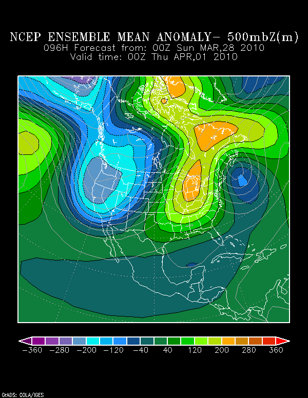
The models are finally showing a nice ridge of high pressure beginning to build over the eastern US early this week, with a trough of low pressure over the western US (the thin gray lines on the plot above). This pattern is great news if you want southerly surface winds advecting warm, moist air up into the Southern Plains.
The map below, also from the Earth System Research Lab, is a model forecast of 500mb (mid-level atmosphere) height anomalies for the same time as above (7pm Central Time on Wednesday). What you should take from this map is that there is higher-than-normal pressure (higher heights; i.e., the ridge)) in the eastern US and lower-than-normal pressure (lower heights; i.e., the trough) in the western US.

A potentially good piece of news for storm chasers is that the southerly winds can give us the warm temperatures and higher dewpoints that we need for strong thunderstorms to form. Moreover, the trough in the West looks like it may be sending a number of shortwave troughs our way, starting late this week. Those troughs provide the needed lift for a thunderstorm. As I’ve mentioned before, we’ve had plenty of lift and wind shear for strong thunderstorms, but an overall lack of moisture and instability–at least until next week, shortly after Easter.
Time to gear up for the storm season and batten down the hatches–it looks as if April could be a busy month.
Permalink
03.27.10
Posted in Severe Weather Nowcast at 1:49 pm by Rebekah
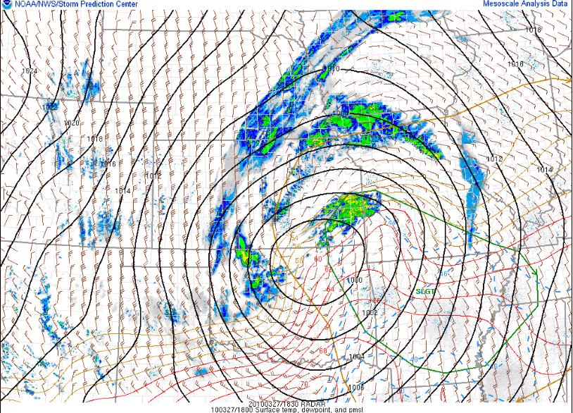
There is a slight chance of severe thunderstorms in Arkansas and southern Missouri this afternoon and evening. The greatest threat is for hail and strong winds, although I would not be completely shocked to hear of a tornado report or two (especially in northern Arkansas, where moisture is greatest).
There is currently an occluded low-pressure system centered over north central Oklahoma/south central Kansas. This low-pressure system is what we call a “cold-core low”; in other words, it is vertically stacked throughout the troposphere (i.e., the upper-level low is situated directly above the surface low) and it is colder within the cyclone than it is outside the cyclone.
Instability and moisture are not great, but this is not as necessary with a cold-core setup. If there is just enough moisture for thunderstorms to form, lift and ambient vorticity (i.e., rotation) in the vicinity of the low could be enough for low-topped supercells to form (think March 8 this year…).

1830Z (1:30pm Central Time) radar image and SPC Day 1 Convective Outlook, with surface winds, pressure (black), temperature (red), and dewpoint (blue).
Permalink
03.26.10
Posted in General News, Weather News at 3:55 pm by Rebekah

Come ye, kings, queens, knights, and peasants to the Medieval Faire in Norman this weekend! From jugglers to jousting, from camel rides to Camelot, thou art sure to find much to amuse thee.
Time: March 26 – 28, from 10am – 7 pm
Place: Reaves Park, Norman, Oklahoma
Website: http://www.medievalfair.org
Weather: Fair and warm today, slightly cooler (high near 60 °F) and windy tomorrow with a slight chance of showers, and cooler (high in the upper 50s) on Sunday with mostly sunny skies and a brisk northwest wind
Ye olde nice weather for the coming week:

Permalink
03.25.10
Posted in Weather Myths at 2:21 pm by Rebekah

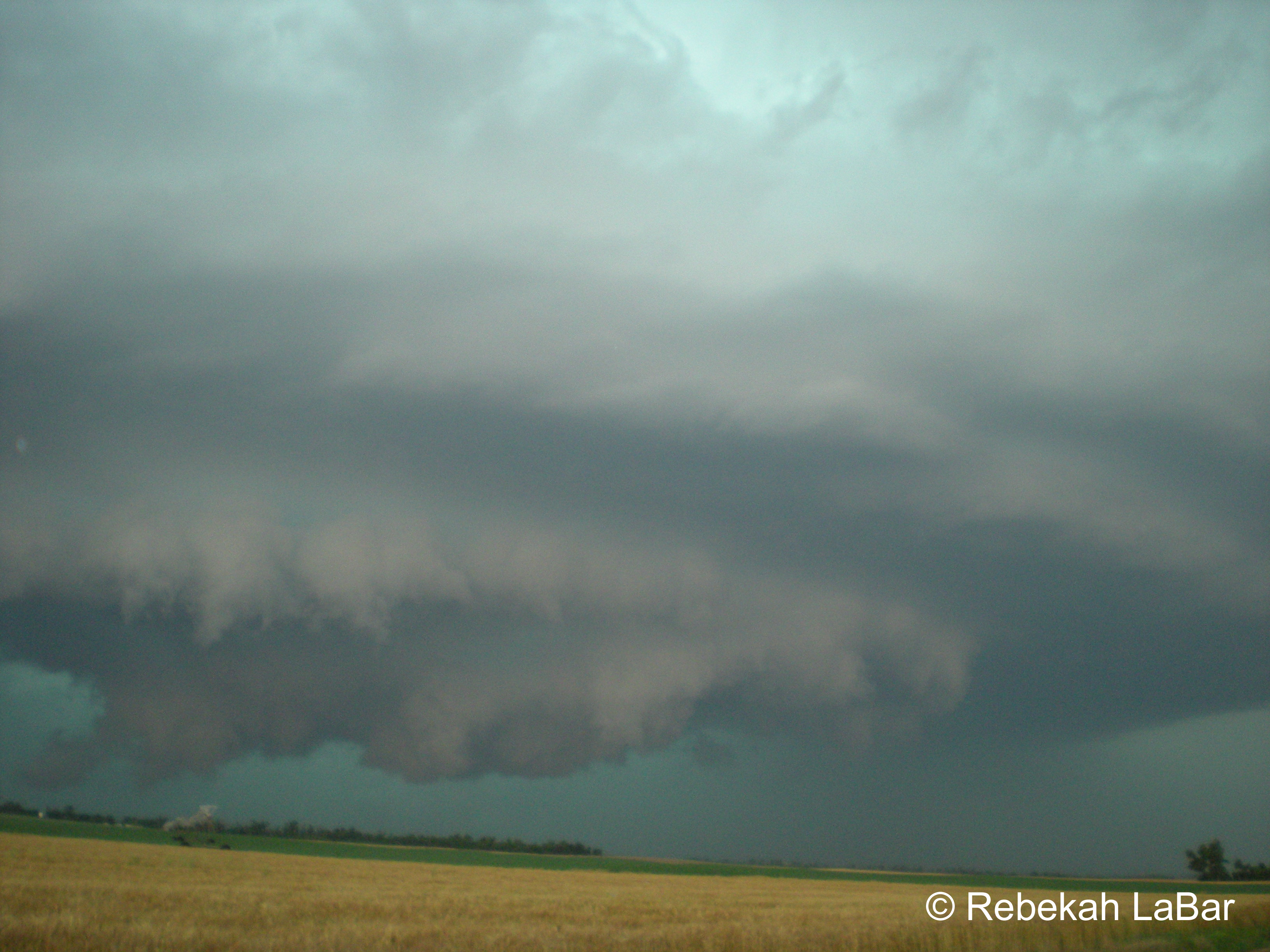
Have you ever heard that when the sky turns green, it means a tornado is coming?
This saying is an oft perpetuated myth, especially in the central US. Truth be told, no one knows for sure what causes a green sky to form. Somehow it’s not a high priority in science right now. 🙂 One thing we do know, though…green skies are often observed with severe thunderstorms, but the sight of a green sky by no means indicates that a tornado is about to form or large hail is about to fall.
Although we are not sure what the exact mechanism is behind the green sky (there are multiple theories you can find on the Internet; some have more credibility than others), the color is likely a result of the liquid water and hail in some strong thunderstorms. Water absorbs and re-emits longwave radiation very well. In fact, water vapor contributes to the greenhouse effect more than any other gas in the atmosphere. One theory is that when sunlight reaches the water droplets and ice within a thunderstorm, the red light is absorbed somewhat, while the green light is reflected back to our eyes. The heavier the precipitation, perhaps the greater the color green.
I chose the name “Green Sky Chaser” for my website and blog because I love the color green. My favorite color of all is a combination of green, blue, and gray: the practically indescribable, pale turquoise color of a stormy sea, and best of all the awe-inspiring color of the sky during some amazing severe storms. I have witnessed several brilliant, blue-green skies while storm chasing (see photo, above; for more photos from my storm chasing adventures, see my website). To me, a green sky means ominous, breath-taking beauty. Tornadoes are not my sole purpose for chasing; the sight of a tornado may be the icing on the cake, but I’d travel many miles just to see lightning, hail, amazing storm structure, and an awesome green sky.
Permalink
« Previous entries Next Page » Next Page »
