12.12.12
Posted in Weather News, Winter Weather at 9:01 pm by Rebekah
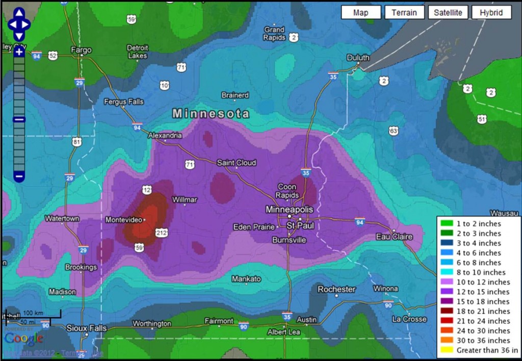
The Midwest snow storm I wrote about this past weekend (Upper Midwest Blizzard) brought record-setting snowfall to parts of Minnesota, including 10.2 inches that fell at Twin Cities, breaking the previous daily record of 7.4 inches in 1961. The heaviest snowfall of the storm was 17.3 inches at Sacred Heart, Minnesota.

NWS Twin Cities snowfall totals from 8th-9th December storm (the link also gives individual snowfall amounts by city).
Permalink
12.09.12
Posted in Weather News, Winter Weather at 3:43 pm by Rebekah
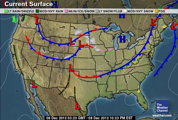
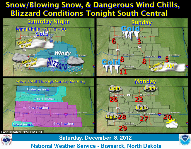
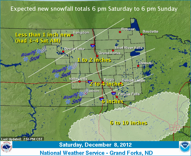
South central North Dakota, northeastern South Dakota, and west central Minnesota are under blizzard warnings today and tonight as a low-pressure system and trailing cold front bring some bitter cold Canadian air and gusty winds to the region.

Big picture from The Weather Channel

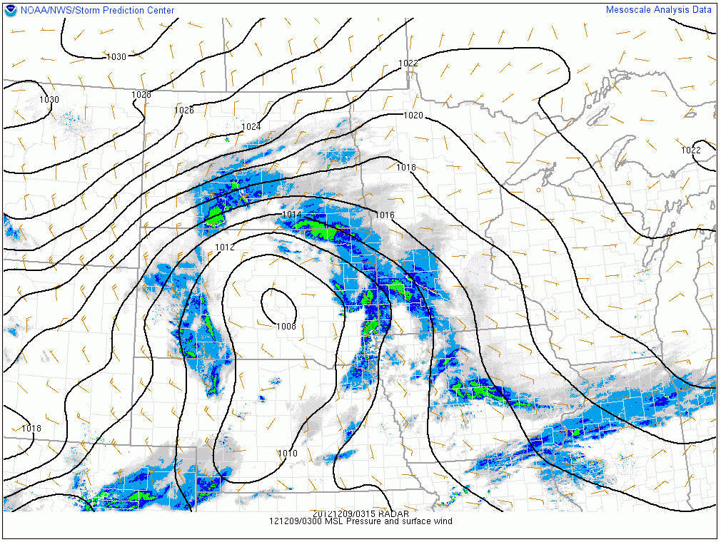
Radar image (0315Z, or 9:15pm Saturday, Central Time) showing snow falling over parts of the Northern Plains, overlaid with surface pressure and winds. Courtesy of the Storm Prediction Center. Click to enlarge.

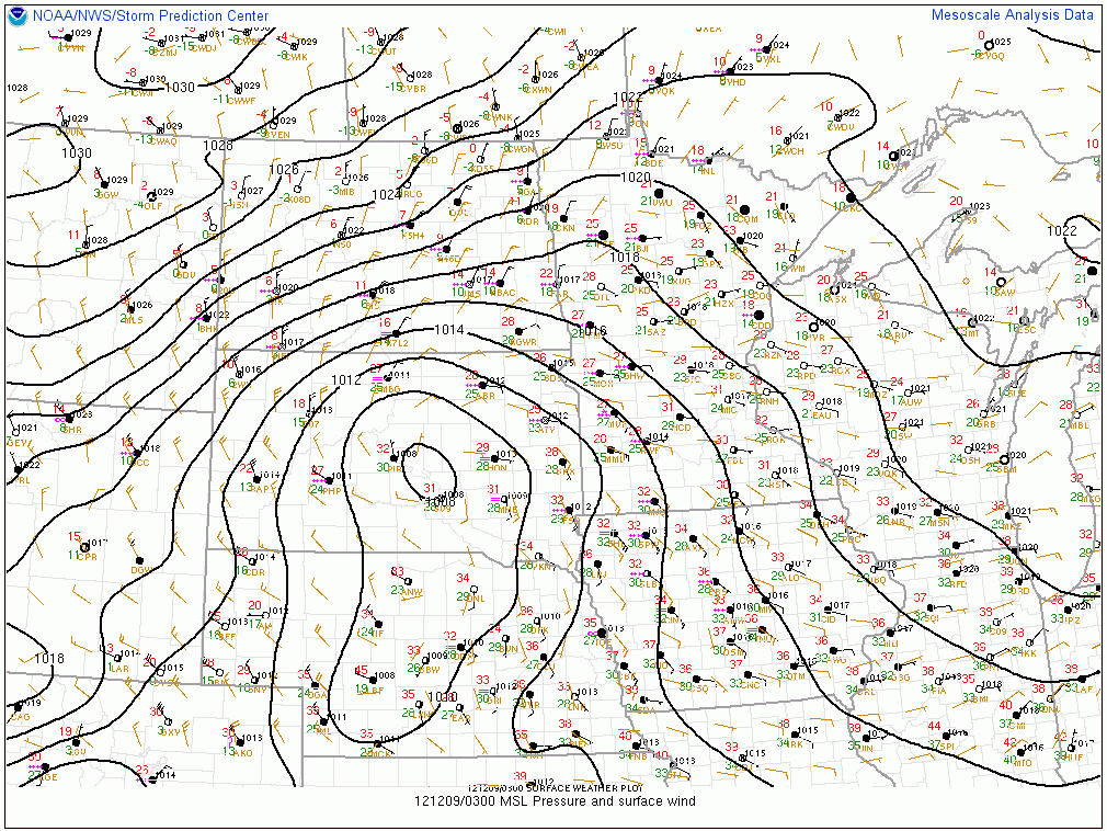
Surface observations (0300Z, or 9pm Saturday, Central Time), overlaid with surface pressure and winds. Courtesy of the Storm Prediction Center. Click to enlarge. The red numbers are the temperature in degrees Fahrenheit; note some near-zero temperatures in North Dakota (and sub-zero at the Canadian border) coming down behind the front! Wind barbs show the direction from which the wind is blowing.
Here is the “weather story” from the NWS Bismarck office:

And from the NWS Grand Forks office:

Temperatures in south central Canada, where a lot of the Plains’ cold air masses develop, are already quite a bit colder than they were at this time last year, which is a good sign if you like wintry weather.
Permalink
12.05.12
Posted in Weather News, Winter Weather at 6:53 pm by Rebekah
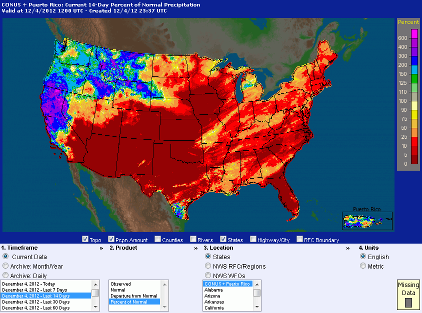
Yesterday I showed a couple maps from the NWS depicting recent precipitation in Washington; now let’s take a look at precipitation across the entire lower 48.

Percent of normal precipitation across the CONUS and Puerto Rico over the last 14 days (click to enlarge), from the NWS.
Two things immediately stand out to me here.
- The majority of the US has been very dry in the last couple weeks. Actually many of these regions have been in a drought for quite some time. It’s also been abnormally warm in places; some of my friends in Oklahoma and Texas have been happy (or unhappy) at the unseasonably warm temperatures lately.
- The West Coast has been abnormally wet lately. As I’ve talked about recently, parts of the West Coast have been pounded with strong weather systems bringing lots of warm, moist air, leading to heavy rains, floods, and landslides. California has been hit especially hard. Large parts of the state have seen over 300% (even over 500%) of their normal rainfall recently.
As to what we can expect for this winter, it can be hard to say. Early predictions for the season, which are usually based heavily on the phase of ENSO (El Niño / La Niña), were shaken up after the expected El Niño failed to develop. We’re currently in a neutral phase, which means there isn’t a high degree of confidence in the season-long predictions.
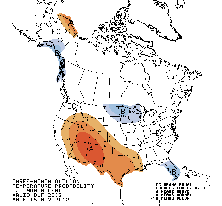
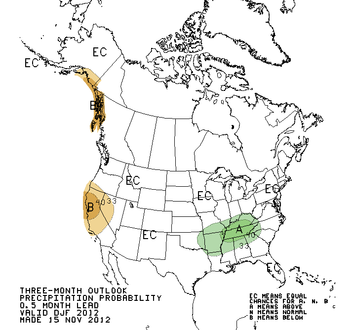
Still, here’s the latest outlook from the Climate Prediction Center.

December through February temperature probability outlook. This shows a good chance for a warmer-than-normal southwestern US, with a colder-than-normal upper Midwest (I have a friend in North Dakota who isn’t too excited at the prospects of his first full winter there being a particularly chilly one!) and Florida.

December through February precipitation probability outlook. Looks pretty normal except for a decent chance of a drier-than-normal California and a wetter-than-normal Kentucky and Tennessee. So far the prediction isn’t looking very accurate for California, but after a wet start to the winter, I’m sure they’re hoping they start trending more towards this forecast!
Permalink
02.26.11
Posted in Weather News, Winter Weather at 8:00 am by Rebekah
The last few days have brought cold temperatures and snow to the Pacific Northwest. Even western Washington and northwestern Oregon received a rare few inches of snow, prompting a visit to Seattle from The Weather Channel’s meteorologist Chris Warren.
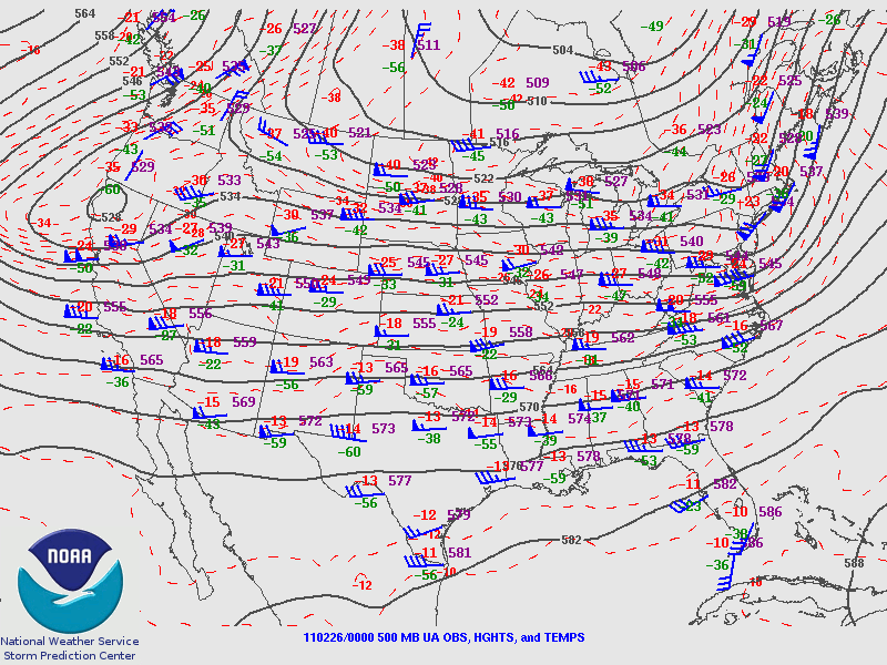
The trough associated with this storm system is dipping a bit further south into central California this morning, where cold air will advance behind a front and surface low moving over the Great Basin.

Friday night’s 500 mb analysis from the Storm Prediction Center, showing the trough over the West Coast.
This cold air is bringing snow early this morning down to at least 1000 feet in the San Francisco Bay Area, and it is even possible that a few flakes may fall at sea level in the Bay Area. As of 11 pm Pacific Time last night, light snow was already confirmed in the San Francisco metro.
It has not snowed in downtown San Francisco since February 1976.
Record cold and a few inches of snow is also forecast for southern California, as a stream of moisture is coming up from the tropics (the Pineapple Express); snow levels in the Los Angeles area could drop to 500 feet.
Record lows were set Friday morning in Seattle, Washington (21 °F) and Billings, Montana (-14 °F), and more records could be broken tomorrow morning. A few examples of California record lows that may be threatened (info from The Weather Channel) include Los Angeles (38 °F), Long Beach (37 °F), and Sacramento (28 °F).

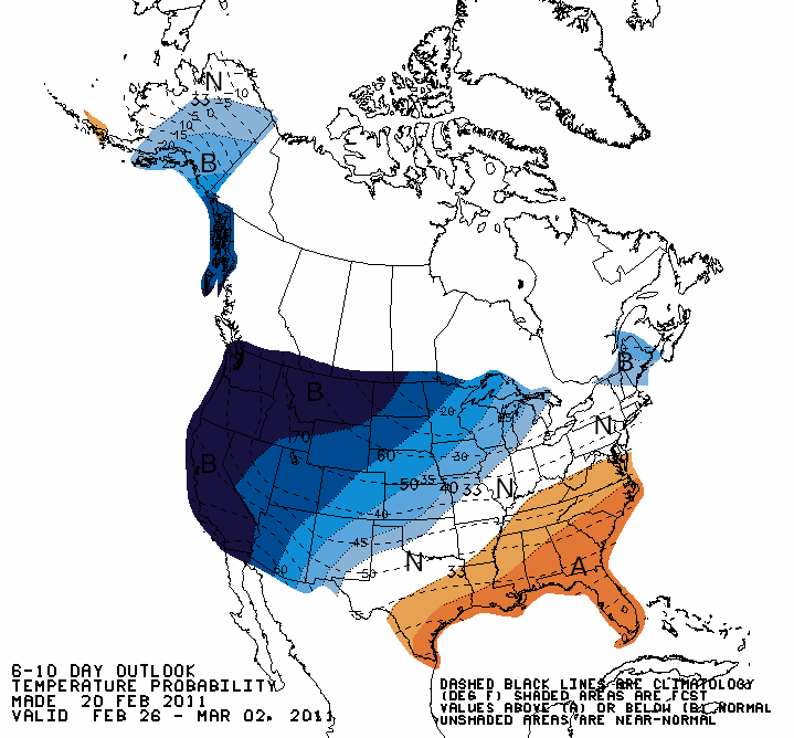
Climate Prediction Center outlook for temperatures from today through Wednesday, showing well below average temperatures expected across the West Coast.
Note also that this unusual cold follows record California warmth earlier in February (e.g., San Francisco experienced some 70 and 80-degree weather).
Permalink
02.15.11
Posted in Non-US Weather, Weather News, Winter Weather at 8:00 am by Rebekah
This week’s post in the global weather and climate series features Gangneung (Kangnŭng), Gangwon-do, South Korea.

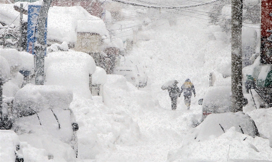
Heavy snow in Gangneung on Feb. 14, 2011. Photo by Lee Sang-hak / Yonhap via Reuters
Gangneung (Kangnŭng) is a city of about 230,000 people in Gangwon-do province, South Korea. Situated on the east coast of the country, Gangneung lies between the Sea of Japan (East Sea) and the Baekdu mountain ridge. The beautiful valleys and mountains around Gangneung, as well as the pine forests and sandy beaches, make this city a popular tourist destination. There are also many festivals that take place in Gangneung.

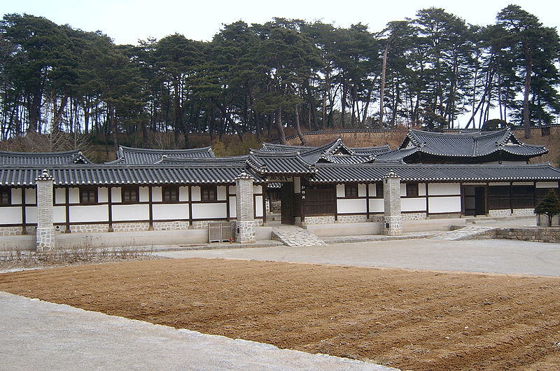
Seongyojang, a 19th century country house outside of Gangneung. From Wikipedia
A few more facts about Gangneung (from Wikipedia):
- Time zone: Korea Standard Time (UTC+9)
- Elevation: varies…from about 30 ft (9 m) to around 100 ft (30 m)…higher in the hills
- Climate zone: Humid subtropical
- Average high temperature: 63 °F (17 °C)
- Average low temperature: 48 °F (9 °C)
- Average annual high/low temperature range: 41 to 83 °F (5 to 28 °C) / 26 to 70 °F (-3 to 21 °C)
- Average annual precipitation: 55 inches (1,402 mm)
Weather: Eastern South Korea has been experiencing record snowfalls lately. Gangneung recently observed a 24-hr snowfall of 30.6 inches (77.7 cm), the greatest 24-hr snowfall since records began in 1911. This heavy snow caused hundreds of roofs to collapse and stranded cars in huge drifts of snow.
High temperatures this week are expected to be in the mid to upper 30s (°F), with lows around 20 °F. Snow is not uncommon this time of year, but this has been an uncommonly cold winter for North Korea and snowy winter for eastern South Korea. Newspapers in South Korea are calling this a “snow bomb”, similar to recent US terms popularized by the media such as “snowpocalypse” and “snowmaggedon”.
For weather maps and information on current and forecast Gangneung weather, see Weather Underground and Weather Online UK (maps and models).
For more information on Gangneung, here’s a link to Wikipedia.
Next Tuesday I plan to take a look at the climate and weather in another part of the globe. As always, if you have any suggestions for future cities, please leave a comment!
Permalink
« Previous entries Next Page » Next Page »
