02.28.10
Posted in General News at 7:56 pm by Rebekah
Congratulations Canada! The Vancouver 2010 Olympics had some great moments, and although the US will go home with the most medals, Team Canada received the most gold. The US/Canada hockey game today was great; I was on the edge of my seat, screaming at my TV towards the end of the game, and couldn’t have been more excited when Zach Parise scored a goal with less than 25 seconds left, to force the game into overtime. I was disappointed that the US couldn’t pull off the upset, but somehow it seemed fitting that Canada should win gold in Vancouver on the final day of the Olympics, and I certainly don’t begrudge them a gold medal in hockey.
In light of the recent snowstorms in the Northeast, and the media’s constant desire to over-hype everything, I found this article rather amusing: http://www.msnbc.msn.com/id/35627330/ns/weather/ What was even more amusing was the response I heard from some of the meteorological community, including from some of those who were “quoted” in the article.
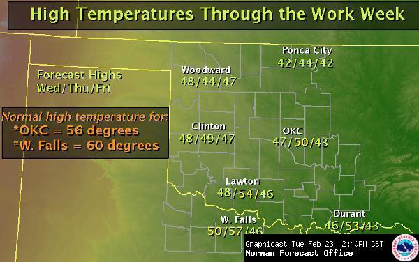
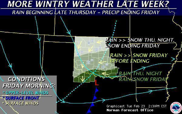
Central Oklahoma may get a little snow tomorrow, but it looks like we may be starting to head towards some warmer temperatures towards the end of the week.
Happy Birthday to my sister Caitlin today! 🙂
Permalink
02.23.10
Posted in Weather News at 5:12 pm by Rebekah
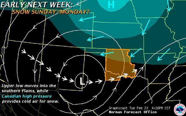
‘Tis a strange world when in the Northern Hemisphere, one must travel north for sun and south for snow. While the northern (especially northwestern) US experiences an early spring, those of us in the southern US continue to enjoy (or not) our below-normal temperatures as we look to yet another possibly heavy snow event–in March.
See below–


Snow is falling all around Dallas today; just south of Dallas there are already 4 to 5 inch snow reports. March is sure to come in like a lion this year! 🙂
Permalink
02.21.10
Posted in General News at 4:15 pm by Rebekah
Surprise, surprise…the GFS model is no longer looking good for chasing on Saturday. 🙂 A couple of rather vigorous-looking troughs are now forecast to move through the Southern Plains on Thursday and Sunday…I’ll certainly keep a close eye on this situation, but it’s not looking quite as interesting.
I woke up at about 3:30 this morning to the sound of thunder. It was very exciting to just see lightning and hear thunder again! A squall line/MCS was stretched from Kansas to Texas.
As usual, I’ve been so busy lately I have not been able to spend as much time working on my website as I would like. My goal is to get all of my chase logs, photos, and videos posted before the first chase of the year. As it looks like that first decent chase may be another couple weeks or so, I *might* be able to get that done. I hope to start working on 2007 chase logs this week, and then the two from 2006 and three from 2005. I’ve also got more work to do on my weather app for the forecast page. That may take a little while yet before I reveal what I’ve been working on. Somehow I’m afraid it won’t look nearly as impressive as the many lines of code that it will take to get the little app up and running. 🙂
Team USA is playing Team Canada tonight in Olympic men’s ice hockey. I’ve found the Olympics pretty interesting this year; I’ve even watched a bit of curling for the first time. That has got to be one of the strangest sports, yet it is so mesmerizing.
To close this random post, check out this video on YouTube where a NASA rocket flies through some cirrus clouds. It is absolutely amazing. You’ll see a shockwave travel throughout the cirrus clouds and obliterate a sundog!
Sonic Boom Meets Sundog
Permalink
02.20.10
Posted in Severe Weather Forecast at 12:27 pm by Rebekah
Saturday, February 27, 2010…just another cool and stable day, or the first Southern Plains supercell storm chase day of the year? I can dream, right? 🙂
A lot can change in 180 hours, so at this point it’s all wishcasting. Based on the GFS model, a negatively-tilted trough is forecast to dig in to the Oklahoma/Texas Panhandle region by 00Z on the 28th. A closed, upper-level low is over eastern Colorado/western Kansas and positive vorticity advection is occurring is southwest Oklahoma and western Kansas. There is also plenty of warm-air advection in Oklahoma and Kansas (especially in western Oklahoma).
A surface low is forecast in eastern Colorado, and it looks like a cold front may extend south of the low into the Texas Panhandle. The model shows southeast surface winds over northern Texas, Oklahoma, and southern Kansas. Warmest temperatures in the region may be in the mid-50s in western Oklahoma, southwest Kansas, and the eastern Texas Panhandle; temperatures in the Lawton, OK to Wichita Falls, TX area may reach the lower 60s. Dewpoints could reach the lower 50s (highest around Wichita Falls).
CAPE values are forecast to be between 750 and 1000 J/kg in western Oklahoma (not terrific, but could be worse). Both direction and speed wind shear look like they could be sufficient for supercells with even a marginal tornado threat, especially as a low-level jet is forecast in central Oklahoma and central Kansas.
It looks like the biggest problem with regard to severe thunderstorm formation may be the cap…forecast soundings show a high cloud layer over western Oklahoma, which may prevent the surface from receiving enough solar heating to break the cap. IF this can occur (i.e., if the high clouds are able to clear out), and this is a huge if, I think we could be looking at the first decent storm chase opportunity west of I-35 this year, especially from Hobart to Lawton, OK to Wichita Falls, TX.
Stay tuned!
Permalink
02.16.10
Posted in Weather News at 11:26 am by Rebekah
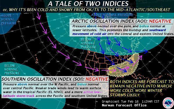
As I recently mentioned how El Niño and the North Atlantic Oscillation (or in the following figure, the closely related Arctic Oscillation) are responsible at least in some part for the cold, snowy weather in the southern and eastern US, I thought I’d post the following weather graphic from the National Weather Service Norman office today.
At least it’s nice and sunny in central Oklahoma this week, and may get up to near 60 °F on Thursday before it cools down a bit and starts to rain again. 🙂

Permalink
« Previous entries Next Page » Next Page »
