05.27.11
Posted in Severe Weather Post-analysis at 10:54 am by Rebekah
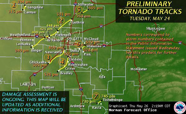
The Norman National Weather Service has upgraded the Binger/El Reno/Piedmont/Guthrie tornado, the Chickasha/Blanchard/Newcastle tornado, and the Washington/Goldsby tornado to EF4. They say that the damage surveys are not done, though, so any of these could even be upgraded later to EF5.
The second of these three tornadoes was the one headed for northwest Norman, south Moore, and possibly downtown Oklahoma City if it had not occluded, and the third was the one headed for the National Weather Center and south Norman if it had not occluded.
Here is the public information statement from the National Weather Service with more info on these tornadoes: http://www.srh.noaa.gov/oun/?n=events-20110524-pns1
Permalink
05.26.11
Posted in Severe Weather Post-analysis at 11:22 pm by Rebekah
The Norman National Weather Service has put out more information on their page for the 24 May 2011 Oklahoma tornado outbreak.
So far they have rated 4 of the 7 confirmed tornadoes as EF3s, though these ratings could be raised (and probably will be) pending further damage analysis.
The following map shows an updated map of the preliminary tornado tracks, with times the tornadoes were on the ground.

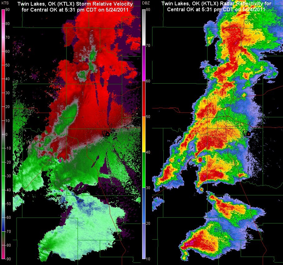
The following images show the storm-relative velocity and radar reflectivity for the tornadic supercells approaching the Oklahoma City metro area. Click to enlarge.

Permalink
05.25.11
Posted in Severe Weather Post-analysis at 7:23 pm by Rebekah

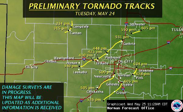
Here is the Norman National Weather Service map of yesterday’s preliminary tornado tracks.
They are working on the damage surveys and have information on this page about the outbreak. So far they have rated the Canton multi-vortex tornado as an EF3, and many of the other tornadoes as at least EF3 (some of these are likely to go up).
There is another high risk for severe weather today in the central Mississippi River Valley, and so far there have been 56 tornado reports.
Permalink
05.24.11
Posted in Severe Weather Post-analysis at 9:34 pm by Rebekah

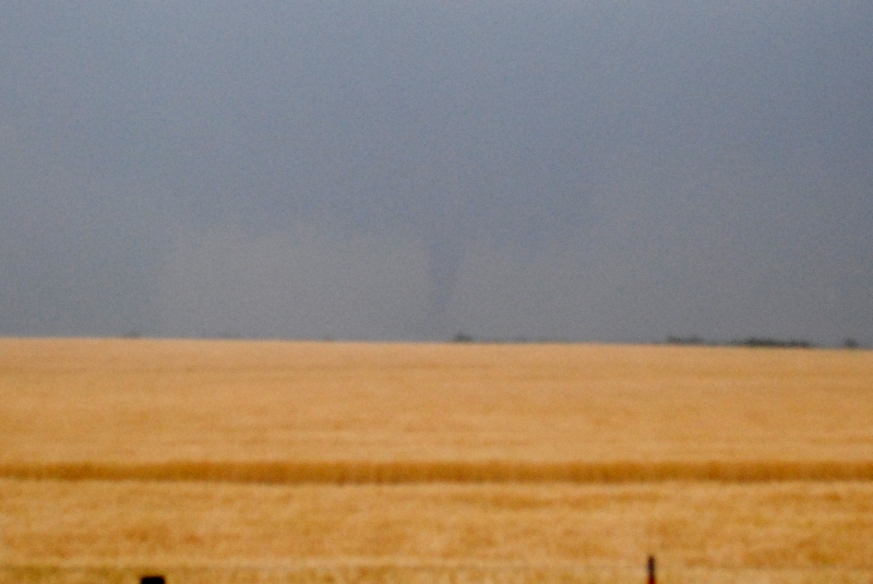
We saw two tornadoes today, a multi-vortex near Canton, Oklahoma at 3:20 pm and the rope-out stage of an elephant trunk tornado near Fairview at about 3:48 pm.
My photos didn’t turn out very well (the above photo is from the touchdown of the Canton tornado), as the rain was starting to fall and my camera had trouble focusing…plus I was busy trying to call in the tornadoes and plot our next route.
The high risk was certainly warranted today, and props to the forecasters for nailing this one. Sadly, there were many large, destructive tornadoes that affected many cities from Kansas to Texas. I thought for a while that my home was in the crosshairs, but the tornadoes lifted just in time. My heart is very heavy tonight for those who were hit by the storms, and for some areas it’s not over yet.
Permalink
05.08.11
Posted in Severe Weather Post-analysis at 10:24 am by Rebekah
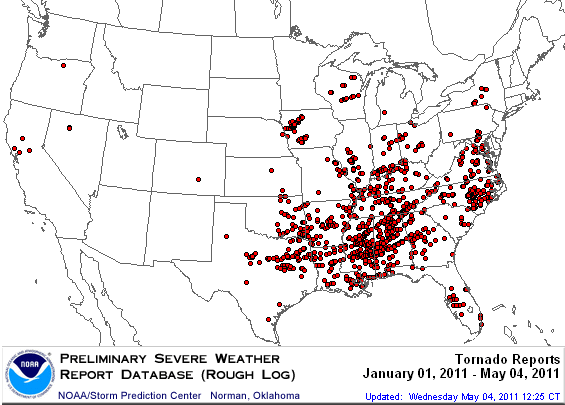
A look at the preliminary number of tornado reports so far this year shows a general lack of tornadoes west of I-35 in the Plains.

It is nearly mid-May already, and this year is proving especially difficult for Plains storm chasers, despite the large number of tornadoes so far.
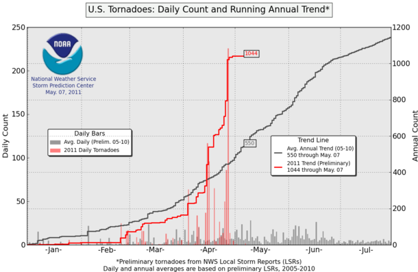
The following graph shows the running count of tornado reports this year as compared to the average annual number based on tornado reports from 2005 through 2010. As you can see, a few tornado outbreaks in April have brought this year’s tornado report count to nearly twice the average.

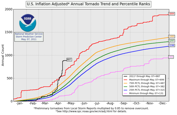
The following graph shows the “inflation-adjusted” number of tornadoes for 2011 (adjusted to account for some tornadoes being counted more than once) compared with percentiles based on averages from 1954 through 2007. Again, note that we are currently well above the maximum recorded number of tornadoes for this time of year!

Are the Plains going to heat up any time soon? That remains to be seen. It does look like at some point this week we may get a dryline day in western Oklahoma, perhaps on Wednesday, that may yield some tornadic supercells. There also may be a chance for some supercells and chasing weather later in the month.
The map and charts are from the Storm Prediction Center, and can be found at the following links: http://www.spc.noaa.gov/climo/online/monthly/2011_annual_summary.html and http://www.spc.noaa.gov/wcm/.
Permalink
« Previous entries Next Page » Next Page »
