05.22.11
Posted in Severe Weather Nowcast, Weather News at 4:31 pm by Rebekah

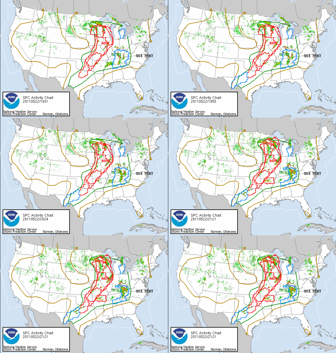
There is more tornadic activity in parts of the Plains today, albeit the eastern Plains.
There may be a couple setups to tempt me to chase tomorrow and Tuesday as well, however there once again may not be enough lift for decent storms tomorrow (the trough may be too far west).
I’ve only got another couple of weeks to chase storms…
Permalink
02.27.11
Posted in Severe Weather Nowcast at 2:37 pm by Rebekah

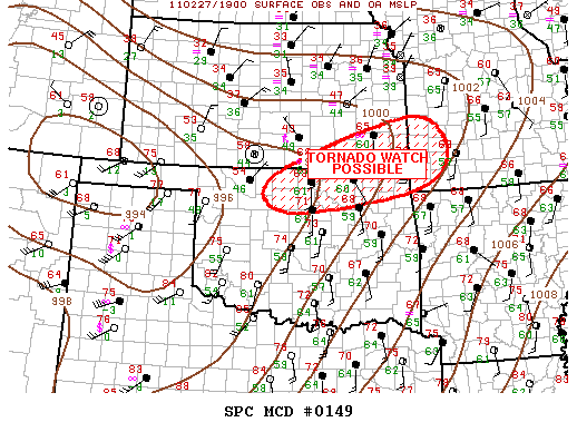
2:12 pm CDT mesoscale discussion graphic from the Storm Prediction Center.
I changed my mind about chasing today, and Jeff and I are on our way up I-35. We’re about 40 miles from Blackwell, Oklahoma, which is around my target area.
There is a nice cumulus field through western Oklahoma, MLCAPE is increasing to above 1500 J/kg in northwest Oklahoma (SBCAPE is above 2500 in western Oklahoma), lapse rates are fairly steep, dewpoints are in the low 60s, and 0 to 6 km bulk shear over much of western and northern Oklahoma is around 60 knots.
A dryline is sharpening in far western Oklahoma, and a warm front is stretching up from southern into eastern Kansas. A surface low is intensifying along the western Kansas/Oklahoma border, in response to a deep shortwave trough heading into the Texas Panhandle.
My expectations are fairly low, but there is a decent chance that there could be a supercell or two up around the Kansas/Oklahoma border late this afternoon. Some elevated storms have already formed along the warm front, but we’re hoping for more surface-based storms closer to the triple point.
Follow Green Sky Chaser on Twitter and Facebook for weather, chasing, and blog updates.
Permalink
08.30.10
Posted in Non-US Weather, Severe Weather Nowcast, Tropical Weather, Weather News at 8:23 pm by Rebekah
There’s so much going on today weatherwise, it would be difficult to discuss it all, or even to just pick one topic. So tonight I’ll just stick with showing a few maps and noting a few highlights of each.
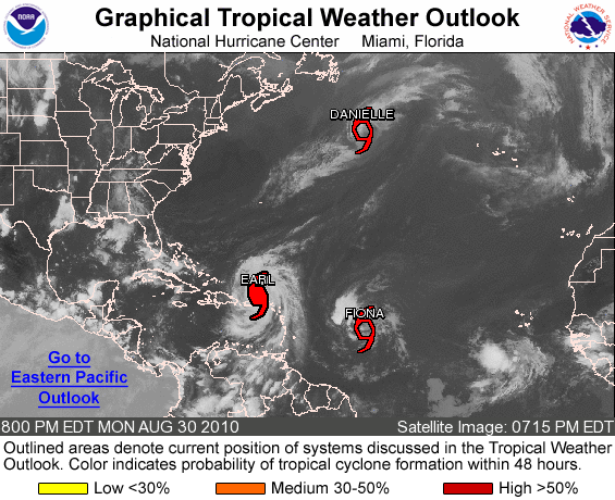
First up: tropical cyclones in the Atlantic.

Figure from the National Hurricane Center.
The big story today is Earl, now a Category 4 hurricane with estimated sustained winds of 135 mph and a central minimum pressure of 938 mb, the lowest pressure in the Atlantic Basin since Hurricane Ike in 2008 (935 mb). Earl could become a borderline Category 5 hurricane tomorrow, when the cyclone is expected to peak at 150 mph (Category 5 has winds of over 155 mph).
Earl has brought heavy rain and strong winds to the Leeward Islands and Puerto Rico today, but is starting to move west-northwest away from Puerto Rico. Earl’s eye is expected to remain offshore, but some of the outer bands could affect the New England Coast by the end of the week.
Tropical Storm Fiona formed this evening, but is expected to remain weak. Danielle is now a tropical storm as well, moving well off into the north central Atlantic.
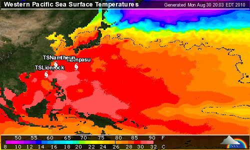
Second: tropical cyclones in the western Pacific.

Figure from Weather Underground.
The western Pacific has been surprisingly quiet so far this year, but there are currently three tropical cyclones in this ocean basin as well. Typhoon Kompasu, with maximum sustained winds of 105 mph, is currently a Category 2 on the Saffir-Simpson scale and is forecast to become a Category 3 as it enters the East China Sea tomorrow. This typhoon is expected to hit the western North/South Korea border as a Category 2 on Thursday.
Tropical Storm Lionrock, with maximum sustained winds of 65 mph, is forecast to become a Category 1 tomorrow and make landfall as a tropical storm in southeast China (just west of Taiwan) on Thursday.
Tropical Storm Namtheun, with maximum sustained winds of 45 mph, is moving southwest and is expected to dissipate between Taiwan and China by Thursday, after running into Lionrock.
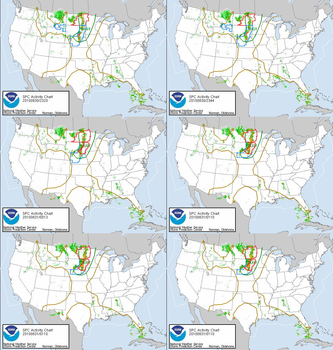
Third: severe thunderstorms in the Northern Plains.

Figure from the Storm Prediction Center.
A trough in the western United States is providing a chance for severe weather today and tonight in the Northern Plains. There is currently a line of thunderstorms from the Nebraska/South Dakota border up into Canada. None of these storms are particularly strong at the moment, but there were tornado warnings out earlier this evening in South Dakota.
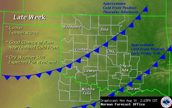
Fourth: rain and cooler weather in Oklahoma.

Figure from the National Weather Service in Norman.
We finally have showers and thunderstorms back in the forecast for this week! We are also expecting another cold front Thursday night, cooling down the temperatures a bit again for the weekend.
Autumn is on its way!
For up-to-date weather and website/blog updates, follow Green Sky Chaser on Twitter.
Permalink
03.27.10
Posted in Severe Weather Nowcast at 1:49 pm by Rebekah
There is a slight chance of severe thunderstorms in Arkansas and southern Missouri this afternoon and evening. The greatest threat is for hail and strong winds, although I would not be completely shocked to hear of a tornado report or two (especially in northern Arkansas, where moisture is greatest).
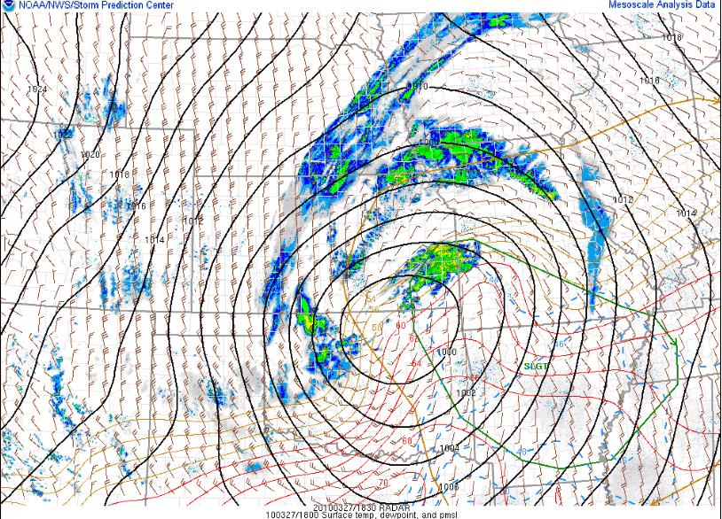
There is currently an occluded low-pressure system centered over north central Oklahoma/south central Kansas. This low-pressure system is what we call a “cold-core low”; in other words, it is vertically stacked throughout the troposphere (i.e., the upper-level low is situated directly above the surface low) and it is colder within the cyclone than it is outside the cyclone.
Instability and moisture are not great, but this is not as necessary with a cold-core setup. If there is just enough moisture for thunderstorms to form, lift and ambient vorticity (i.e., rotation) in the vicinity of the low could be enough for low-topped supercells to form (think March 8 this year…).

1830Z (1:30pm Central Time) radar image and SPC Day 1 Convective Outlook, with surface winds, pressure (black), temperature (red), and dewpoint (blue).
Permalink
03.10.10
Posted in General News, Severe Weather Forecast, Severe Weather Nowcast at 11:34 pm by Rebekah
I posted my chase log and photos from Monday on my website. See the homepage link on the right side of this page. Or click here.
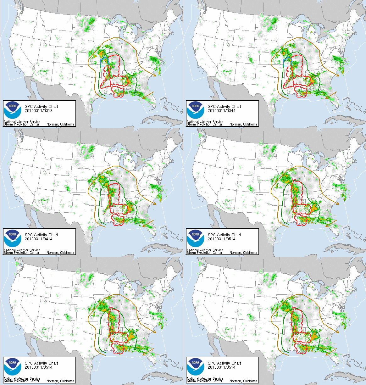
A large upper-level low pressure system, associated fronts and a dryline, moderate instability, and ample wind shear are responsible for severe thunderstorms breaking out today from Kansas to Texas to Alabama. Five tornadoes have been reported so far in Arkansas and Louisiana, with more possible tonight in the Mississippi River Valley region.
A ridge of high pressure is building on the East Coast, and this is going to block the upper-low and keep it from moving out into the Atlantic for the next few days. This means more severe weather could be possible in the eastern US over the next couple of days.

And now, for a special announcement–I have re-discovered Armor All. Sunday afternoon, in anticipation of chasing on Monday, I decided to thoroughly clean out my car. My dashboard was getting woefully dusty, and my trunk was a mess. The other day at Walmart, I saw some Armor All cleaning wipes and remembered that when I was a kid, my Dad wanted me to use Armor All to clean and protect the interior of our car. I don’t think I thought much of the product back then; probably because I didn’t always do the best job of wiping down the car. Or I just didn’t appreciate it. Anyway, I tried using the cleaning wipes on my dashboard on Sunday, and I was blown away. I think my car must have been really dusty and dirty, because I wiped down every inch of the dashboard, console, and door panels, and now–my car glows! Well, at least on the inside. So go out and buy some Armor All–it will make your car look new and happy again. Thanks, Dad. 🙂
Permalink
« Previous entries Next Page » Next Page »
