07.30.13
Posted in Weather Education, Weather News at 2:34 pm by Rebekah
This time of year is getting into wildfire season in the West, and here in Washington we’ve already had some significant ones.
I’ve been back in the Pacific Northwest for the last couple of weeks, busily running around Washington and Oregon visiting family and friends and preparing for my move to New Zealand on Sunday. This past Saturday my parents and I drove down for an overnight trip to see my grandparents in central Oregon. We had to take a longer-than-normal way down, as a wildfire in south central Washington had forced the highway over Satus Pass to be shut down.
Sadly the weather has been prime lately for fires, and we saw a fair amount of smoke around on the drive down and back. We’ve had some strong ridges of high pressure sitting over the Northwest lately, bringing 90s to 100s F temperatures and a general lack of rainfall. It obviously doesn’t take much then to start a fire when the wind picks up, and most of these fires tend to be caused by a careless toss of a cigarette.
Coming back to central Washington Sunday evening, as we crested the last ridge before looking down into Kittitas Valley (where my parents live), we got a good look at the smoke from a new fire growing just over the opposite ridge.
What I was most fascinated with was the towering pyrocumulus clouds.
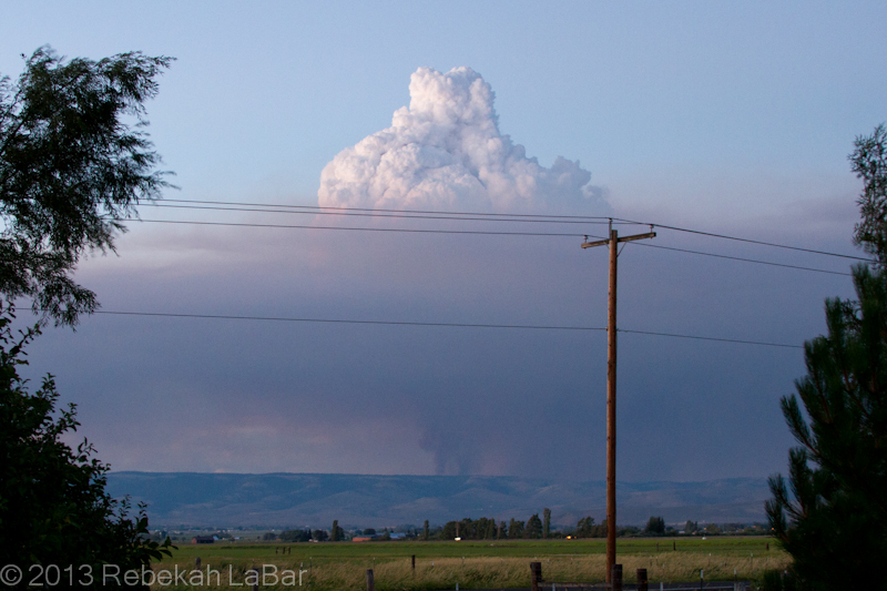
Pyrocumulus cloud growing above a smoke column northeast of Ellensburg, WA
The basic principle behind cloud formation is water vapor condensation onto tiny particles called cloud condensation nuclei (CCN). These CCN could be sand, dust, salt, … or in this case ash.
A fire in effect seeds the atmosphere, and the hot air above the flames can generate rapid and robust convection (rising air) that results in a puffy-looking (cumulus) cloud if there is enough moisture in the air.
Such cumulus clouds that form as a result of fires and volcanoes are known as pyrocumulus, or even pyrocumulonimbus if they grow large enough to produce a heavy shower or thunderstorm.
While the phenomenon is not uncommon, I had rarely seen such a well-defined example. A visible satellite loop from Sunday shows a series of pyrocumulus forming over the fire’s hotspot, and then moving off to the east (due to upper-level winds) as others form over the fire.
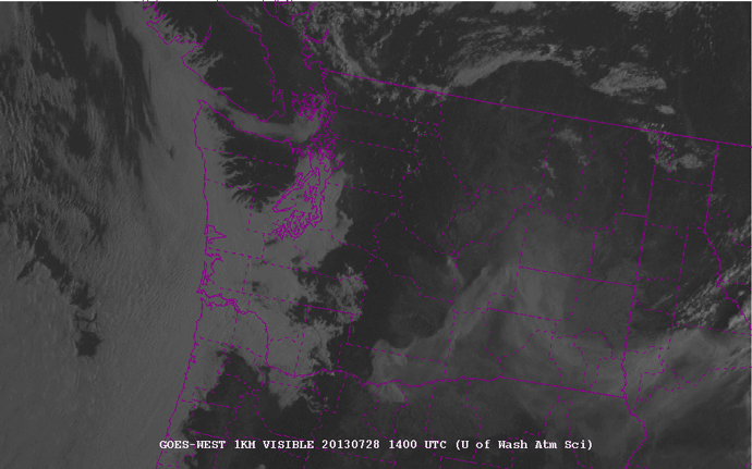
1-km visible satellite loop of Washington State, from 7am to 9pm local (PDT) on 28 July 2013. Counties are outlined in purple. Courtesy of the University of Washington - http://www.atmos.washington.edu/cgi-bin/list.cgi?vis1km. Click to enlarge.
The fire in the northeast corner of Kittitas County (center of the state) is evident from the eastward-moving smoke plume. Later in the afternoon, about 3pm (2200 UTC), you can start to see the series of whitish knobs forming on top of the fire. These are the pyrocumulus. They really start to explode around 5 to 6pm (0000-0200 UTC).
As an aside you can also see the fire in south central Washington, although there are not so many pronounced pyrocumulus clouds on the smoke plume.
There may have been a little bit of rain falling from the cloud, but a radar loop showed a stationary spot of reflectivity that was in the location of the fire. Fires are not always visible on radar, but sometimes they are large enough for the ash particles to reflect the radar beam and appear to be stationary “rain” showers.
I didn’t save a loop, but here’s a single image from Sunday night, showing the fire to my northeast.
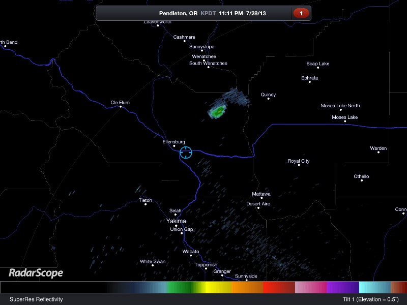
RadarScope image of the Pendleton, Oregon radar reflectivity. The blue circle shows my location, and the greenish blob to my northeast is the fire.
InciWeb (Incident Information System) has updated information and maps of the fire (and others) here: Colockum Tarps Fire. News articles today say nearly 70 square miles are up in flames and it is only 5% contained. The winds are fairly light now, but later in the week we could get a bit more wind and a slight chance for thunderstorms.
So far the fire has been mostly on grasslands, but if it spreads further west, it will become much harder to fight in the timberland. And if it spreads further south, it may start to threaten some homes and a wind farm.
Here’s hoping the firefighters get some better weather for fighting the fires, and everyone and their homes stay safe.
Permalink
12.12.12
Posted in Weather News, Winter Weather at 9:01 pm by Rebekah
The Midwest snow storm I wrote about this past weekend (Upper Midwest Blizzard) brought record-setting snowfall to parts of Minnesota, including 10.2 inches that fell at Twin Cities, breaking the previous daily record of 7.4 inches in 1961. The heaviest snowfall of the storm was 17.3 inches at Sacred Heart, Minnesota.

NWS Twin Cities snowfall totals from 8th-9th December storm (the link also gives individual snowfall amounts by city).
Permalink
12.11.12
Posted in Non-US Weather, Weather News at 6:18 pm by Rebekah
This week’s post in the World Wide Weather series features Salzburg, Austria (click for a Yahoo! maps link).

Salzburg Old Town on the Salzach River, photographer Jiuguang Wang, from Wikipedia
Salzburg, on the western border of Austria with Germany, is situated on the northern edge of the Austrian Alps. First settled around the 5th century BC, Salzburg means “Salt Castle”; in the 8th century, barges carrying salt would come down the Salzach River and be subject to a toll.
Today, the city is famous for baroque architecture, the birthplace of Wolfgang Amadeus Mozart, and the stage for the events of “The Sound of Music”. Every summer there is a large festival celebrating classical music and operas.
A few more facts about Salzburg (from Wikipedia):
- Time zone: Central European Time (UTC + 1) or Central European Summer Time (UTC +2)
- Elevation: 1,391 ft (424 m)
- Climate zone: Cool and humid
- Average high temperature: 58 °F (14 °C)
- Average low temperature: 41 °F (5 °C)
- Average annual high/low temperature range: 38 to 76 °F (3 to 24 °C) / 25 to 56 °F (-4 to 14 °C)
- Record high temperature: 100 °F (38 °C)
- Record low temperature: -16 °F (-27 °C)
- Average annual precipitation: 47 inches (1,184 mm)
- Average annual snowfall: 44 inches (113 cm)
Weather: While usually relatively cool due to its location in the foothills of the Alps, Salzburg has a fairly large temperature range throughout the year because of its continental location. Orographic lift (air being forced up the mountains) is responsible for a good amount of rain especially in the summer months, and snow is common in the winter.
Early this week Salzburg is experiencing temperatures below freezing and moderate snowfall. A high pressure system will enter the region later in the week, bringing sunnier skies and milder weather.

Forecast for Austria for Tuesday morning, temperatures in degrees Celsius. Salzburg is circled. From Austria’s Central Institute for Meteorology and Geodynamics.

Weather map of Europe, valid 00Z on Tuesday, 11 December, from Austria’s Central Institute for Meteorology and Geodynamics. Note the frontal boundary leaving central Europe, with the high pressure system over the UK soon to pass through.

Surface pressure, GFS model, valid at 00Z on Thursday, 13 December, from Weather Online UK. This shows the high pressure system now over Austria, which will bring some breaks in the clouds and precipitation.
For weather maps and information on current and forecast Salzburg weather, check out Austria’s Central Institute for Meteorology and Geodynamics (if your German is as bad as mine, use Google to translate the page), Weather Underground, and Weather Online UK (good for maps and models across the globe). For more information on Salzburg, check out Wikipedia.
Permalink
12.09.12
Posted in Weather News, Winter Weather at 3:43 pm by Rebekah
South central North Dakota, northeastern South Dakota, and west central Minnesota are under blizzard warnings today and tonight as a low-pressure system and trailing cold front bring some bitter cold Canadian air and gusty winds to the region.

Big picture from The Weather Channel

Radar image (0315Z, or 9:15pm Saturday, Central Time) showing snow falling over parts of the Northern Plains, overlaid with surface pressure and winds. Courtesy of the Storm Prediction Center. Click to enlarge.

Surface observations (0300Z, or 9pm Saturday, Central Time), overlaid with surface pressure and winds. Courtesy of the Storm Prediction Center. Click to enlarge. The red numbers are the temperature in degrees Fahrenheit; note some near-zero temperatures in North Dakota (and sub-zero at the Canadian border) coming down behind the front! Wind barbs show the direction from which the wind is blowing.
Here is the “weather story” from the NWS Bismarck office:

And from the NWS Grand Forks office:

Temperatures in south central Canada, where a lot of the Plains’ cold air masses develop, are already quite a bit colder than they were at this time last year, which is a good sign if you like wintry weather.
Permalink
12.06.12
Posted in Non-US Weather, Weather News at 7:11 pm by Rebekah
Two tornadoes struck the northern side of the North Island of New Zealand today, sadly killing three people in the Auckland suburb of Hobsonville and leaving many others homeless.
Check out these news articles for details, photos, and videos:
That last link is a video someone took out their window as the tornado passed–definitely not the safest thing to do! If a tornado is moving through your neighborhood, you should find shelter, if not underground then in a small interior room. Above all else stay away from windows; fortunately the videographer did not appear to have sustained any injuries.
On the other side of the world, a beautiful waterspout touched down off the northwestern coast of Italy.
This waterspout reminded me of a recent Italian tornado (The Weather Channel video link) and waterspout earlier this week (YouTube link) as well as amazing video of an Australian waterspout last month (Facebook link).
Update: The New Zealand tornado event has since been surveyed and determined to more likely have been a microburst. A MetService blog about the event may be found here: Hobsonville wind storm Thursday 6 December 2012.
Permalink
« Previous entries Next Page » Next Page »
