07.30.13
Northwest Fires and Pyrocumulus
This time of year is getting into wildfire season in the West, and here in Washington we’ve already had some significant ones.
I’ve been back in the Pacific Northwest for the last couple of weeks, busily running around Washington and Oregon visiting family and friends and preparing for my move to New Zealand on Sunday. This past Saturday my parents and I drove down for an overnight trip to see my grandparents in central Oregon. We had to take a longer-than-normal way down, as a wildfire in south central Washington had forced the highway over Satus Pass to be shut down.
Sadly the weather has been prime lately for fires, and we saw a fair amount of smoke around on the drive down and back. We’ve had some strong ridges of high pressure sitting over the Northwest lately, bringing 90s to 100s F temperatures and a general lack of rainfall. It obviously doesn’t take much then to start a fire when the wind picks up, and most of these fires tend to be caused by a careless toss of a cigarette.
Coming back to central Washington Sunday evening, as we crested the last ridge before looking down into Kittitas Valley (where my parents live), we got a good look at the smoke from a new fire growing just over the opposite ridge.
What I was most fascinated with was the towering pyrocumulus clouds.
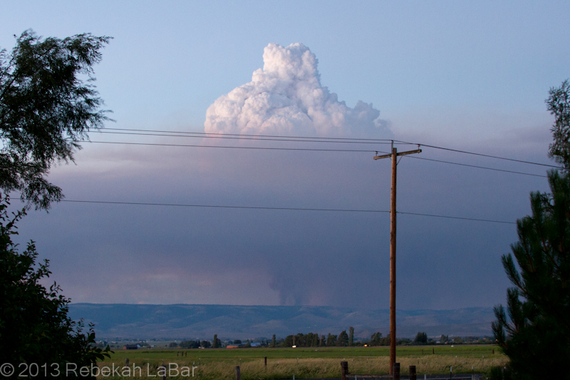
Pyrocumulus cloud growing above a smoke column northeast of Ellensburg, WA
The basic principle behind cloud formation is water vapor condensation onto tiny particles called cloud condensation nuclei (CCN). These CCN could be sand, dust, salt, … or in this case ash.
A fire in effect seeds the atmosphere, and the hot air above the flames can generate rapid and robust convection (rising air) that results in a puffy-looking (cumulus) cloud if there is enough moisture in the air.
Such cumulus clouds that form as a result of fires and volcanoes are known as pyrocumulus, or even pyrocumulonimbus if they grow large enough to produce a heavy shower or thunderstorm.
While the phenomenon is not uncommon, I had rarely seen such a well-defined example. A visible satellite loop from Sunday shows a series of pyrocumulus forming over the fire’s hotspot, and then moving off to the east (due to upper-level winds) as others form over the fire.
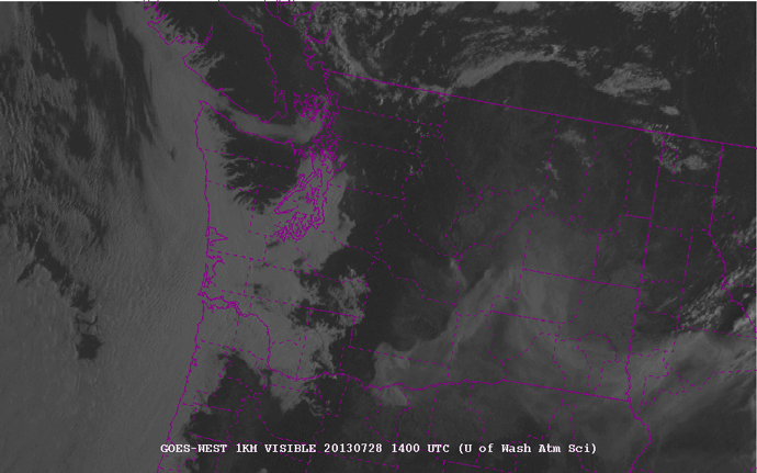
1-km visible satellite loop of Washington State, from 7am to 9pm local (PDT) on 28 July 2013. Counties are outlined in purple. Courtesy of the University of Washington - http://www.atmos.washington.edu/cgi-bin/list.cgi?vis1km. Click to enlarge.
The fire in the northeast corner of Kittitas County (center of the state) is evident from the eastward-moving smoke plume. Later in the afternoon, about 3pm (2200 UTC), you can start to see the series of whitish knobs forming on top of the fire. These are the pyrocumulus. They really start to explode around 5 to 6pm (0000-0200 UTC).
As an aside you can also see the fire in south central Washington, although there are not so many pronounced pyrocumulus clouds on the smoke plume.
There may have been a little bit of rain falling from the cloud, but a radar loop showed a stationary spot of reflectivity that was in the location of the fire. Fires are not always visible on radar, but sometimes they are large enough for the ash particles to reflect the radar beam and appear to be stationary “rain” showers.
I didn’t save a loop, but here’s a single image from Sunday night, showing the fire to my northeast.
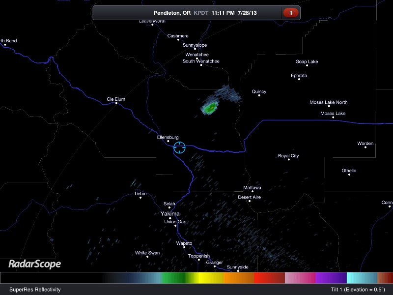
RadarScope image of the Pendleton, Oregon radar reflectivity. The blue circle shows my location, and the greenish blob to my northeast is the fire.
InciWeb (Incident Information System) has updated information and maps of the fire (and others) here: Colockum Tarps Fire. News articles today say nearly 70 square miles are up in flames and it is only 5% contained. The winds are fairly light now, but later in the week we could get a bit more wind and a slight chance for thunderstorms.
So far the fire has been mostly on grasslands, but if it spreads further west, it will become much harder to fight in the timberland. And if it spreads further south, it may start to threaten some homes and a wind farm.
Here’s hoping the firefighters get some better weather for fighting the fires, and everyone and their homes stay safe.