01.11.11
Posted in Weather News, Winter Weather at 9:06 pm by Rebekah

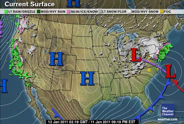
Tonight’s surface analysis from The Weather Channel shows most of the U.S. in the grips of a strong, large area of high pressure. This high pressure has ushered in cold, dry air for much of the U.S.
Perhaps the biggest story tonight, though, is that the low pressure center over Ohio, associated with a deep, upper-level trough, should merge late tonight with the low moving up the Atlantic Coast. This secondary low is what tracked along the Gulf Coast early in the week, aiding in the snow and ice storms of the Southeast.
As the smaller low moves up the coast tonight, an area of upper-level divergence on the east side of the trough (what’s causing the low in Ohio) will cause the surface low to intensify. The two areas of surface low pressure will appear to merge below the trough, and the pressure of the resulting surface low is expected to rapidly drop.
Models are showing that the pressure of this low could drop by 28 millibars in 24 hours, which is well within the definition of a “bomb cyclone” (low pressure center drop of 24 millibars in 24 hours). Currently, the pressure of both lows is about 1012 mb.
This extratropical cyclone / nor’easter is expected to result in several inches of snowfall across the Northeast, starting tonight.
In other news, there is also an extratropical cyclone off the Pacific Coast, and this is responsible for strong winds and rain and wintry precipitation along the West Coast. Western Washington and northwestern Oregon are already receiving snow and freezing rain.
Permalink
Posted in Non-US Weather, Weather News at 8:00 am by Rebekah
This week’s post in the global weather and climate series features Antananarivo, Madagascar.

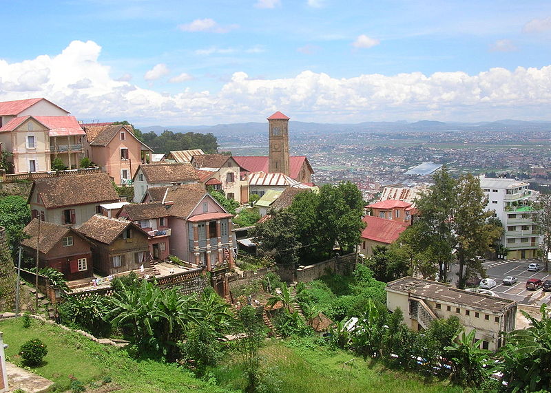
Looking down on Antananarivo, Madagascar. Source: Wikipedia
Situated on a mountain ridge, near the center of the island lengthwise and about 90 miles west of the eastern coast, Antananarivo is the capital of and the largest city in Madagascar. Founded in 1625, by the king of the Merina (an ethnic group from Madagascar), Antananarivo (formerly Tananarive) means “the city of the thousand”, taken from the number of soldiers assigned to guard it. In 1793, the city was made the capital of the Merina kingdom. About one hundred years later, Antananarivo was captured and colonized by the French. Madagascar finally gained independence from the French in 1960.
Today, Antananarivo is the economic and administrative center of Madagascar, with a population (in 2001) of 903,450 (1,403,449 in the metro). Exports include food, cigarettes, and textiles. Antananarivo is home to the University of Madagascar/Antananarivo, an Anglican cathedral and a Roman Catholic cathedral (as well as over 5,000 other church buildings), and Ivato International Airport (with service to Nairobi, Johannesburg, and Paris). Malagasy is the official language of Madagascar, though French is spoken there as well.
A few more facts about Antananarivo (from Wikipedia):
- Time zone: East African Time (UTC+3)
- Average elevation: 4,186 feet (1,276 meters)
- Climate zone: Temperate / subtropical highland
- Average high temperature: 75 °F (24 °C)
- Average low temperature: 57 °F (14 °C)
- Average annual high/low temperature range: 68 to 82 °F (20 to 28 °C) / 51 to 62 °F (10 to 17 °C)
- Record high temperature: 95 °F (35 °C)
- Record low temperature: 34 °F (1 °C)
- Average annual precipitation: 54 inches (1,365 mm)
Weather: At 18.5 °S, Antananarivo lies in the tropics of the Southern Hemisphere, thus the climate is warm and wet; however, the mountains keep the temperature milder than it would be otherwise. The coolest, driest months are from April to October.
Currently, every day this week is forecast to have a high near 82 and a low near 60. Scattered showers and thunderstorms are also forecast every day and night, with only a small amount of rain expected each day.
For weather maps and information on current and forecast Antananarivo weather, see Weather Underground and Weather Online UK.
For more information on Antananarivo, here’s a link to Wikipedia.
Next Tuesday we will take a look at the climate and weather in another part of the globe. As always, if you have any suggestions for future cities, please leave a comment!
Permalink
01.10.11
Posted in Weather Education at 8:00 am by Rebekah
Last Monday we took a look at some basic definitions in meteorology, including meteorology, the atmosphere, weather (as well as why we have weather), and climate.
Today we’re going to start reviewing the elements of weather, starting with temperature.
————————————————–
Elements of Weather
Temperature
Temperature is a measure of the kinetic energy of all the molecules in a substance. The faster the molecules are moving, the higher the temperature. Alternatively, you can think of it the other way around; for example, the warmer a pot of water, the more the water molecules are moving (i.e., the water may eventually evaporate)…or, the colder a pot of water, the less the molecules are moving (i.e., the water may eventually freeze).
Temperature Scales
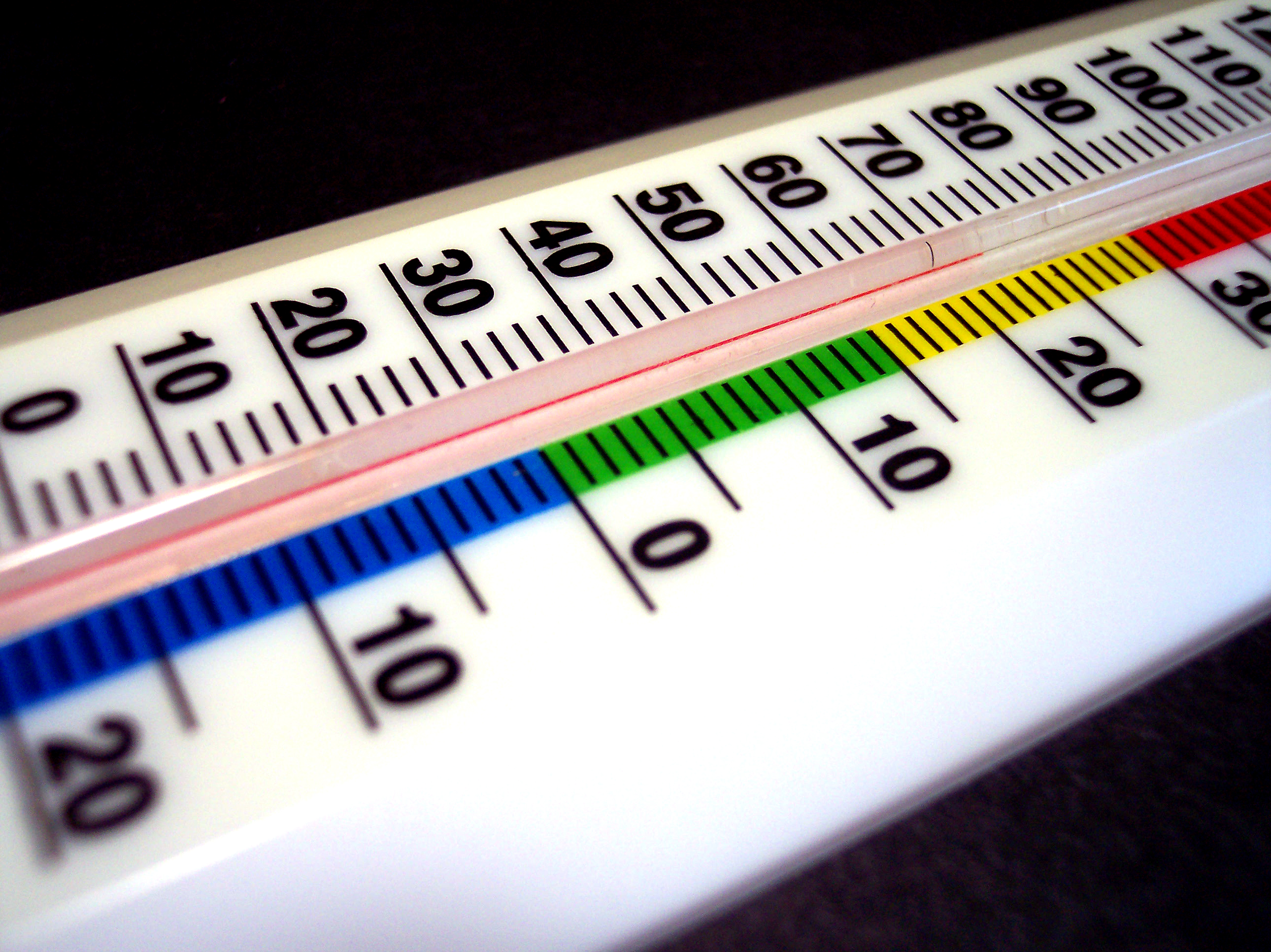
There are 3 primary temperature scales: Fahrenheit, Celsius, and Kelvin. Click here to see more on these temperature scales, including how to convert between the three.
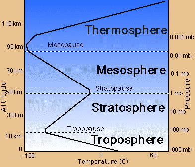
Temperature Structure of the Atmosphere

Source: NASA
Categorized by air temperature, there are four layers of the atmosphere:
- Troposphere – the lowest layer of the atmosphere…air temperature generally decreases with height, as the earth is better than air at absorbing incoming solar radiation (thus it is kept warmer)
- Stratosphere – above the troposphere (the boundary is known as the tropopause)…air temperature generally increases with height, as a layer of ozone efficiently absorbs solar radiation
- Mesosphere – above the stratosphere (the boundary is known as the stratopause)…air temperature generally decreases with height, for the same reason as the troposphere
- Thermosphere – above the mesosphere (the boundary is called the mesopause)…air temperature generally increases with height, as there is such a lack of air molecules (the few molecules that are there do not have to “share” as much solar radiation with other molecules, thus they become more energetic)
————————————————–
Come back next Monday to learn about pressure, another element of weather.
Permalink
01.09.11
Posted in Weather Education at 8:01 am by Rebekah
Have you ever stopped to think what meteorologists and climatologists mean by the words “average” and “normal“?

When your local TV weathercaster tells you that today’s temperature is 10 degrees below normal, do you just assume that average/normal means the average quantity (e.g., temperature) for that time period (e.g., January 9th) over all years in recorded history?
If so, you might be surprised to find that average/normal typically means something else in meteorology and climatology.
The climate of any given place changes over time; the earth as a whole naturally goes through cold, warm, wet, and dry cycles (this is true regardless of man’s impact on the atmosphere). This being the case, taking the average temperature, for example, of New York from the 1800s to 2010 may not give a very good picture of the typical temperature you might expect to find in New York.
In meteorology and climatology, we take the average value of a quantity over a 30-year period ending with the end of the last decade, and call that value the average, or the normal.
This means that from 2001 through 2010, the average annual rainfall for Seattle is defined as the annual rainfall averaged from 1971 through 2000.
Now that we’ve moved on to a new decade, we’ll be moving on to a new set of averages: those from 1981 through 2010.
Will this affect how we define our “normal” weather? Yes. In many cases there will not be much of a difference, but take temperature, for example. The 1970s were cooler than the 2000s, thus the new average temperatures for many places will be warmer.
Permalink
01.08.11
Posted in General News at 5:06 pm by Rebekah
I’ve posted chase logs and photos on the website for June 14 (north Texas shelf clouds), June 15 (east Texas Panhandle thunderstorm), June 23 (north central Oklahoma / south central Kansas thunderstorms), June 24 (southeast Colorado thunderstorm), June 25 (southwest Minnesota supercell and squall line), and June 26 (east South Dakota supercell and squall line). Check it out! I’ll be posting more of these soon.
Permalink
« Previous Page — « Previous entries « Previous Page · Next Page » Next entries » — Next Page »


