02.03.10
Posted in Weather News at 11:24 pm by Rebekah
…that is the question: whether ’tis nobler in the mind to suffer the slings and arrows of outrageous snowstorms…oh, whatever.
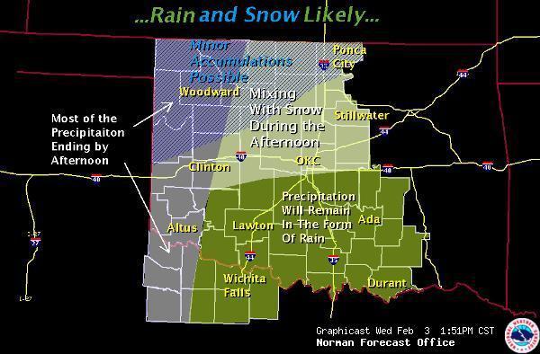
There’s a slight chance of in Oklahoma City and points north tomorrow…and a greater chance next week (even here) with the colder weather. However, the NWS is advertising it as “very wet” snow, as the temperature may only be marginal for snow (at least tomorrow…colder weather is coming again next week).

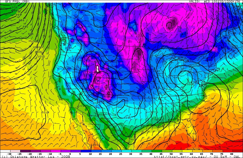
GFS model for 12Z Wednesday, showing a temperature in Norman of about 20F…the NWS is going with 14F for now, though, probably as the models tend to run a little warm this far out (lines are surface pressure, showing high over west central US):


How many days until the first chase setup in the southern Plains?
Permalink
01.30.10
Posted in General News, Weather News at 4:23 pm by Rebekah
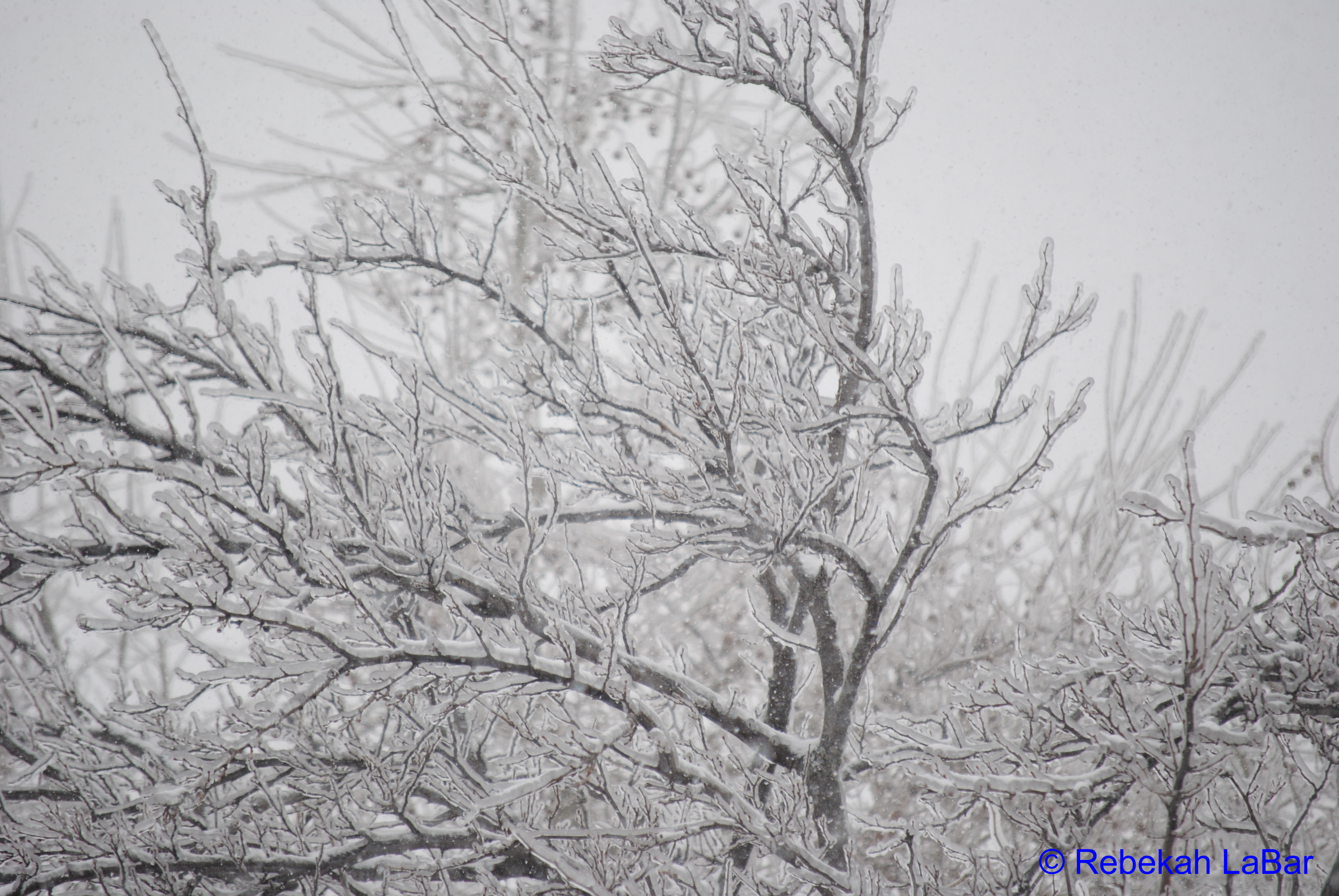
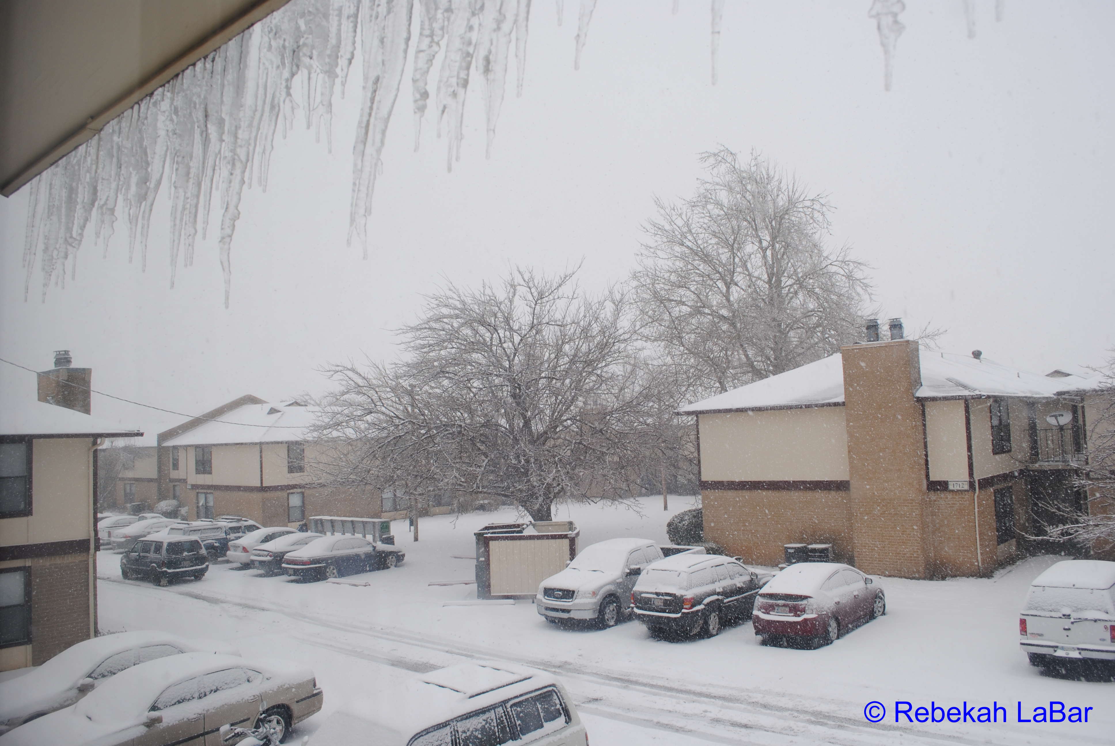
The storm system that wreaked havoc from the Plains to the East Coast has exited the country and is over the Atlantic now. The temperature has stayed in the 20s in Norman today and the sky is overcast, so there’s not much melting going on today. The icicles are dripping, though. I went outside for a bit earlier today to take some photos and measure the snow depth. Around my apartment, I measured an average of 5-7 inches of snow (4.5 inches on my car), with 0.5 to 0.75 inches of ice below that. I measured about 0.5 inches of ice encasing the trees. I also saw some snow drifts of nearly 14 inches.
I designed a slide show of some of my photos and posted it to my website under the photos link: www.greenskychaser.com/photos/photos2010storm.htm The slide show plays in Windows Media Player, but it’s embedded; I don’t know if it will work for people who don’t have Windows Media Player. If you can’t view it, please let me know so I can look into other options. I may eventually move all of my photo galleries into this format.
Expect more updates on the website tomorrow afternoon, including 2008 chase logs and photos, a redesigned forecast page (again!), and possibly a few other changes.
As always, if you have any comments or suggestion, please let me know!
Permalink
01.29.10
Posted in Weather News at 1:27 pm by Rebekah
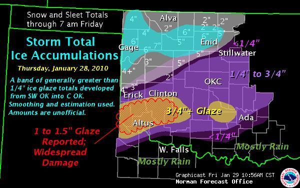
It’s been snowing all day and most of the night. The TV is still calling this “Ice Storm 2010″, even though there is already more snow than there was ice. There was about 0.5” of ice and now a couple of inches of snow and we’re expected to get a few more inches by the end of the day. It should taper off by early evening or so, once the dry air moves in.
Right now the freezing rain and sleet is coming down in Arkansas and Tennessee. The storm is expected to bring ice and snow all the way to the East Coast through tomorrow.
I haven’t ventured outside yet, but if the snow tapers off before dark I may carefully go out to snap a few photos of the trees. As of now I’ve just got some photos of the icicles, ice, and snow outside my window.
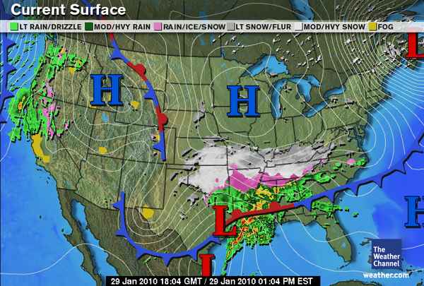
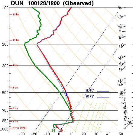
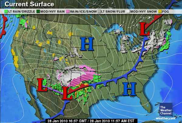
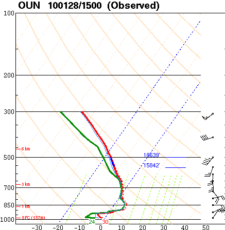
This ice/snow storm is practically a textbook setup, with a large high pressure system bringing arctic air southward from Canada, behind a cold front extending from a strong surface low off the New England coast. There’s also the surface low to our south, complicating matters…while this may be a classic-looking setup, it’s also a complex forecast problem because of the warm-air advection. In the low-levels of the atmosphere, a southerly wind brought relatively warm air from the Gulf of Mexico into the area, and that’s what caused the main problem with forecasting precipitation type (a lot of warm air in the low/mid levels = freezing rain, a shallow layer of warm air above a deep layer of cold air near the surface = sleet, sub-freezing from cloud to ground = snow)…this is apparent on the soundings and upper-air maps. The snow is now coming behind the surface low, which is now in southeast Texas.

Ice/Snow Storm Summary

Surface Analysis at about 12PM


Permalink
01.28.10
Posted in Weather News at 3:47 pm by Rebekah
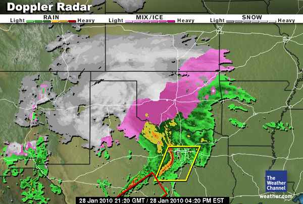
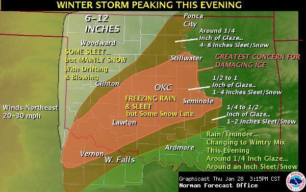
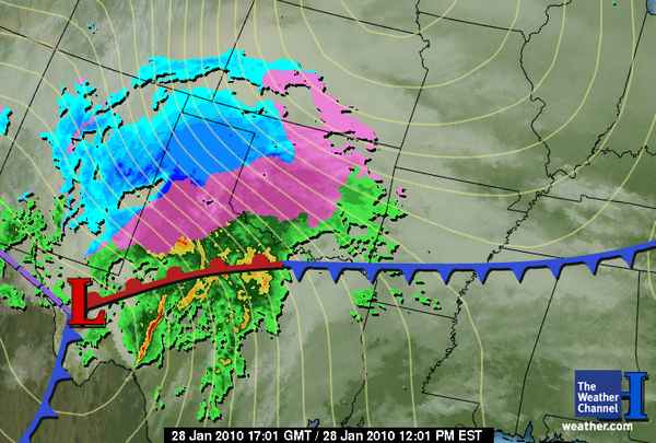
It’s been pouring down sleet here for a little while now. I’m trying to keep the heat in my apartment up in case the power goes out and I can’t heat the place. There’s a thick glaze over the trees outside my apartment now, and the screens on my windows are so coated with ice I can’t see through them. Here are a couple of updated graphics, the first one is radar, showing two watch boxes as well–a severe thunderstorm watch in north Texas and a tornado watch in south Texas! Not too far south of here the temperatures are in the upper 60s and lower 70s. The other image shows an updated image of the NWS forecast, now expecting up to 1 inch of ice and more sleet and snow on top of that.
I’ll also post the latest special sounding from Norman, at noon today (18Z), still showing a great freezing rain sounding. On the sounding you can tell the surface cold layer was getting deeper (from 15Z) and the elevated warm layer was getting shallower, indicating that the atmosphere was getting closer to producing sleet.


Permalink
Posted in Weather News at 1:02 pm by Rebekah
Central Oklahoma is right in the middle of a large ice storm. Several-inch-long icicles have already formed on my apartment building and my car is iced over. OU canceled classes for noon onward today and all day tomorrow. I had a class at 10-11 this morning, but skipped it as I didn’t want to risk driving in the ice. Most flights (95%) have been canceled at the Oklahoma City airport today as freezing rain has been steadily falling for the past several hours. Winds have calmed down a bit since last night; only 10 mph winds in Norman at the moment, but if the winds go back up to 20mph or so, we could be in big trouble as far as trees and power lines coming down by tomorrow morning.
The freezing rain is expected to continue throughout the day, turning into sleet by late today and snow over night into tomorrow. The NWS is forecasting up to 3/4-inch of ice and 1-2 inches of sleet and snow…KFOR TV (Oklahoma City news) is predicting up to 1.5 inches of ice. They are comparing this ice storm to the epic December 2007 ice storm. It really is a little scary as to how similar this setup appears to be.
Here are a few weather maps from this morning, starting with a country-wide look at the current setup of fronts and pressure systems as well as radar:

This is the “perfect” setup for an ice storm, blizzard, and severe weather (hail and tornadoes forecast in south Texas!). Now for a zoomed-in look at Oklahoma:

A special 15Z (9am local time) sounding at Norman showed an ideal profile for freezing rain. Ice and snow falling from the clouds melts in the deep warm layer, then the liquid water becomes “supercooled” as it falls into a shallow sub-freezing layer just above the surface.

I think I’m somewhat prepared for the power to go out, though I think it’s difficult to be fully prepared. Power outages are already being reported in southwest Oklahoma. Photos of trees bent over with ice are showing up on TV, and those photos are from just southwest of here, with the worst of the storm headed this way.
Permalink
« Previous Page — « Previous entries « Previous Page · Next Page » Next entries » — Next Page »
