02.28.11
Posted in Weather Education at 4:00 pm by Rebekah
Meteorologists use two main methods to forecast the weather: analysis of weather data and analysis of weather models. In order to know the state of the atmosphere as accurately as possible, and in order to have the best data to feed into the weather models, we must first take good weather measurements.
A discussion of weather measurements can be broken up into three categories: surface observations, upper-air observations, and remote sensing (e.g., radar and satellite). Today we will touch on surface observations.
Surface Observations
Most surface observations are taken hourly around the world, and include measurements of temperature, dewpoint, pressure, wind speed and direction, cloud cover, precipitation, and current weather (e.g., thunderstorms or fog).
Temperature
Temperature is measured with a thermometer, though not all thermometers today have to be mercury-filled. Temperature can also be measured with an electrical resistor called a thermistor (this is what may be used in your thermostat to help regulate your heater or air conditioner).
Temperature units are given in Fahrenheit (°F), Celsius (°C), or Kelvin (K).
Dewpoint
Dewpoint temperature can not be measured directly, but is calculated from measurements of either the wet-bulb temperature or the relative humidity. Instruments include psychrometers and hygrometers. A psychrometer has two thermometers, one of which has the tip covered by a wet piece of cloth. As the moisture on the cloth evaporates, the temperature on the “wet-bulb” thermometer drops (remember evaporation takes heat, leaving the environment cooler). The drier the air, the more the water evaporates, and the lower the wet-bulb (and dewpoint) temperature.
There are many different types of hygrometers, including electrical ones and ones made of hair. You know how your hair can get frizzy or limp depending on the air’s humidity? Hair hygrometers take advantage of this property, and make humidity measurements based on it.
Dewpoint units are also given in Fahrenheit (°F), Celsius (°C), or Kelvin (K).
Pressure
Pressure was traditionally measured in a mercury barometer. An empty glass tube, closed on the top, would be placed in an open container of mercury, forming a vacuum inside the tube. The higher the pressure, the more the air would push down on the mercury, forcing some of it up the tube.
Today, pressure units are still often given in inches of mercury (in. Hg), though we typically use other types of barometers. Meteorologists report pressure in units of millibars (mb) or hectoPascals (hPa).
Wind
Wind speed is measured with an anemometer. A cup anemometer has three small cups on a horizontal plane, and the faster the wind, the faster the cups spin around. A newer way of measuring both wind speed and direction is with a sonic anemometer. Sonic anemometers just look like a few sticks sticking up, and use sound waves to detect the direction and speed of the wind.
Wind speed units are commonly given in miles per hour (mph), nautical miles per hour (knots), kilometers per hour (km/h), or meters per second (m/s).
Clouds
The amount of cloud cover and the height of the clouds can be measured with a ceilometer. A ceilometer sends up a laser beam which reflects off of clouds. Another way to assess the clouds is to just look out the window. 🙂
Precipitation
Rainfall can be measured with different types of rain gauges. One of my favorite types is the tipping bucket rain gauge, which consists of two small buckets on a seesaw device. When one of the buckets is full, it tips over and empties itself while the other bucket fills up.
Measuring snowfall can be a bit trickier; sometimes snowfall measurements are recorded by someone with a ruler, but there are automated ways of measuring the snow. It’s also important to measure the liquid water equivalent of snow, which is the amount of liquid water if the snow is melted. Even a heavy snow can result in a low liquid water equivalent. A standard snow to water ratio is 10:1 (i.e., 10 inches of snow to 1 inch of water), though a dry snow could be 20:1 or even 40:1 and a very wet snow could be 5:1.
————————————————–
Next Monday we will talk about upper-air observations, including weather balloons.
Follow Green Sky Chaser on Twitter and Facebook for weather, chasing, and blog updates.
Permalink
Posted in Uncategorized at 8:00 am by Rebekah

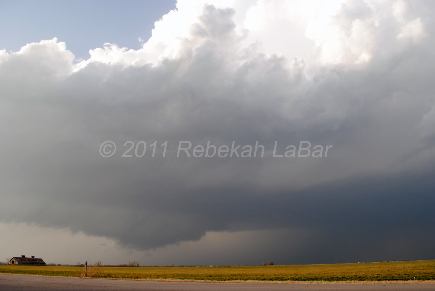
Yesterday we saw a supercell and about three wall clouds in north central Oklahoma, but missed out on the tornadoes this storm later produced, as we gave up just east of Blackwell when the supercell became more outflow dominant and picked up speed. The storm was getting away from us too quickly and we didn’t want to keep following it into worse chase territory (I prefer to stick to chasing west of I-35, as a general rule).
(Special note: this morning’s regularly scheduled weather education post will come later this afternoon.)
Follow Green Sky Chaser on Twitter and Facebook for weather, chasing, and blog updates.
Permalink
02.27.11
Posted in Severe Weather Nowcast at 2:37 pm by Rebekah

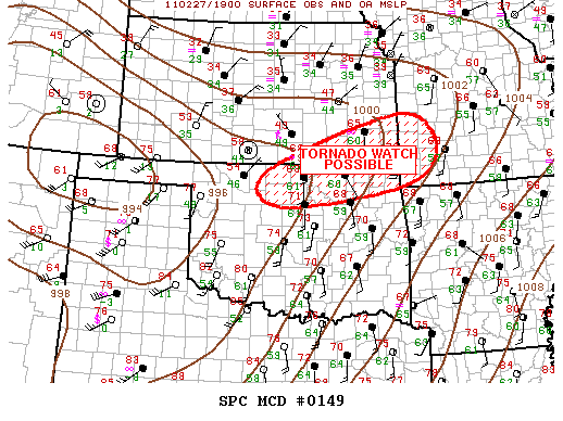
2:12 pm CDT mesoscale discussion graphic from the Storm Prediction Center.
I changed my mind about chasing today, and Jeff and I are on our way up I-35. We’re about 40 miles from Blackwell, Oklahoma, which is around my target area.
There is a nice cumulus field through western Oklahoma, MLCAPE is increasing to above 1500 J/kg in northwest Oklahoma (SBCAPE is above 2500 in western Oklahoma), lapse rates are fairly steep, dewpoints are in the low 60s, and 0 to 6 km bulk shear over much of western and northern Oklahoma is around 60 knots.
A dryline is sharpening in far western Oklahoma, and a warm front is stretching up from southern into eastern Kansas. A surface low is intensifying along the western Kansas/Oklahoma border, in response to a deep shortwave trough heading into the Texas Panhandle.
My expectations are fairly low, but there is a decent chance that there could be a supercell or two up around the Kansas/Oklahoma border late this afternoon. Some elevated storms have already formed along the warm front, but we’re hoping for more surface-based storms closer to the triple point.
Follow Green Sky Chaser on Twitter and Facebook for weather, chasing, and blog updates.
Permalink
Posted in Severe Weather Forecast at 8:00 am by Rebekah
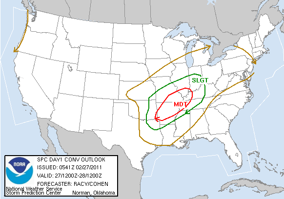
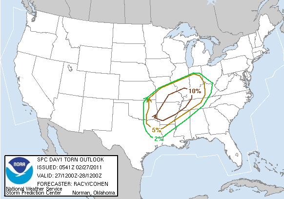
There is another moderate risk for severe storms today, from Arkansas through southeastern Missouri and into the Mississippi River Valley. It does appear that there will be a strong enough cap to prevent very many storms from firing until near or after dark, but there is a chance for an overnight severe weather outbreak.
I again will not be chasing today, and haven’t spent a lot of time looking at this setup…but here’s the 6Z Storm Prediction Center outlook:


Permalink
02.26.11
Posted in Weather News, Winter Weather at 8:00 am by Rebekah
The last few days have brought cold temperatures and snow to the Pacific Northwest. Even western Washington and northwestern Oregon received a rare few inches of snow, prompting a visit to Seattle from The Weather Channel’s meteorologist Chris Warren.
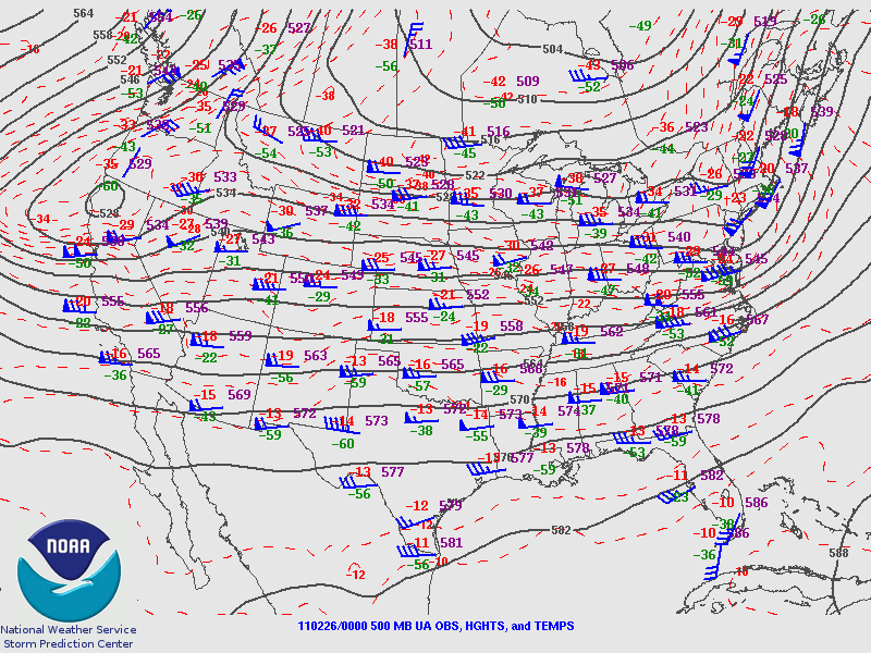
The trough associated with this storm system is dipping a bit further south into central California this morning, where cold air will advance behind a front and surface low moving over the Great Basin.

Friday night’s 500 mb analysis from the Storm Prediction Center, showing the trough over the West Coast.
This cold air is bringing snow early this morning down to at least 1000 feet in the San Francisco Bay Area, and it is even possible that a few flakes may fall at sea level in the Bay Area. As of 11 pm Pacific Time last night, light snow was already confirmed in the San Francisco metro.
It has not snowed in downtown San Francisco since February 1976.
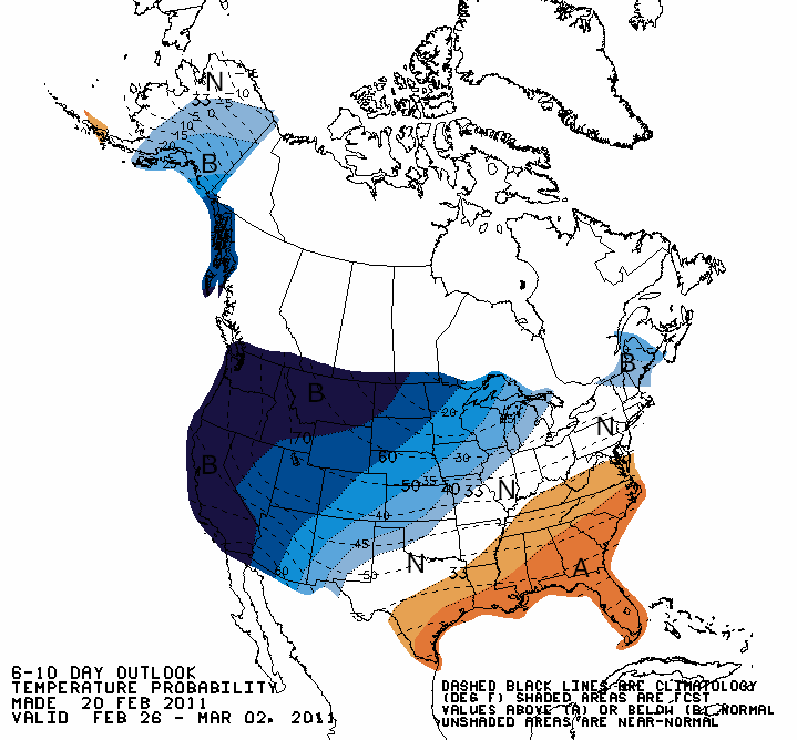
Record cold and a few inches of snow is also forecast for southern California, as a stream of moisture is coming up from the tropics (the Pineapple Express); snow levels in the Los Angeles area could drop to 500 feet.
Record lows were set Friday morning in Seattle, Washington (21 °F) and Billings, Montana (-14 °F), and more records could be broken tomorrow morning. A few examples of California record lows that may be threatened (info from The Weather Channel) include Los Angeles (38 °F), Long Beach (37 °F), and Sacramento (28 °F).

Climate Prediction Center outlook for temperatures from today through Wednesday, showing well below average temperatures expected across the West Coast.
Note also that this unusual cold follows record California warmth earlier in February (e.g., San Francisco experienced some 70 and 80-degree weather).
Follow Green Sky Chaser on Twitter and Facebook for weather, chasing, and blog updates.
Permalink
« Previous entries Next Page » Next Page »
