Target Area: Alva, Oklahoma
Chase Area: Medicine Lodge/St. John, Kansas
Observations: two thunderstorms, mammatus, lightning, and a coyote
Distance: 600 miles
Time: 13 hours, 15 minutes
Chase Team: Jeff Makowski and myself
SPC Convective Outlook: Moderate Risk (Only Slight Risk in our target area) (Click to see SPC products, data, and storm reports)
Chase Setup: A strong trough was moving into the Rockies. The main action this day was up in Iowa, but in our area of interest there was a dryline draped from central Kansas through western Oklahoma. Dewpoints in south central Kansas were near 60, with MLCAPE around 1500 J kg-1. Wind shear was also decent for rotating storms and large hail, provided the storms could form under weak forcing.
Blog Entries:
Next Severe Storms Risk This Weekend (before)
Plains Severe Weather Tomorrow (before)
Chase #3: Off We Go! (during)
Chase #3 Review (after)
Chase Log: The main show this day was tornadoes in Iowa, but I didn't have the time or inclination to go all the way up there, so I decided to just go for the marginal chance for storms along the dryline from west central Kansas through northwest Oklahoma.
We targeted Alva, and drove to just southwest of there only to sit for nearly three hours in a large parking lot. We watched some cumulus along the dryline attempt to bubble up, only to get mixed out and dissipate. Surface dewpoints started in the low 60s, but mostly mixed out to the upper 50s by later in the day. It was also pretty windy, and a lot of dust got kicked up around us.
Around 6 pm, we decided to go north on 281 up to Alva, to find some food and air conditioning. Almost no sooner did we start to go north than we saw a cumulus cloud start to grow outward as well as upward, corresponding with the first blip of the day (for the area) on radar.
We picked some gravel roads to drive on for a while, as shortcuts to the Kansas border, in an effort to intercept the growing storm. This little shower dissipated fairly quickly, but a few more tried to get going there as well.
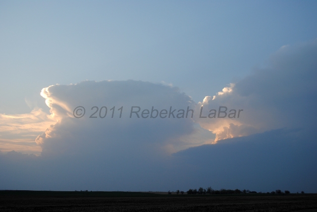
By the time we got to Kansas, a couple of elevated thunderstorms had moved just north of Coldwater. The sun very nicely lit up this convection just before setting. We started to see lightning about this time; we saw quite a bit of intracloud and anvil lightning, with a few cloud-to-ground strikes.
These two storms pretty much combined after this, and raced away to the northeast. When we arrived at Highway 50, near St. John, we headed east to go back to I-35. As we drove along on 50, we saw quite a bit more lightning as it started to get dark. The storm didn't last much after sunset, though.
All in all, the day went about as expected, although I didn't expect to end up so far north in Kansas. It was still a good day in that we saw a couple of decent thunderstorms (the main one may have briefly been a supercell, but we never confirmed if it was rotating or not) and some more mammatus and lightning.
 |
Kiowa County, Kansas storms |