07.30.13
Posted in Weather Education, Weather News at 2:34 pm by Rebekah
This time of year is getting into wildfire season in the West, and here in Washington we’ve already had some significant ones.
I’ve been back in the Pacific Northwest for the last couple of weeks, busily running around Washington and Oregon visiting family and friends and preparing for my move to New Zealand on Sunday. This past Saturday my parents and I drove down for an overnight trip to see my grandparents in central Oregon. We had to take a longer-than-normal way down, as a wildfire in south central Washington had forced the highway over Satus Pass to be shut down.
Sadly the weather has been prime lately for fires, and we saw a fair amount of smoke around on the drive down and back. We’ve had some strong ridges of high pressure sitting over the Northwest lately, bringing 90s to 100s F temperatures and a general lack of rainfall. It obviously doesn’t take much then to start a fire when the wind picks up, and most of these fires tend to be caused by a careless toss of a cigarette.
Coming back to central Washington Sunday evening, as we crested the last ridge before looking down into Kittitas Valley (where my parents live), we got a good look at the smoke from a new fire growing just over the opposite ridge.
What I was most fascinated with was the towering pyrocumulus clouds.
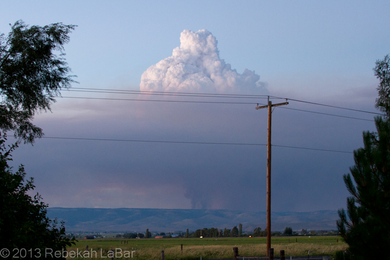
Pyrocumulus cloud growing above a smoke column northeast of Ellensburg, WA
The basic principle behind cloud formation is water vapor condensation onto tiny particles called cloud condensation nuclei (CCN). These CCN could be sand, dust, salt, … or in this case ash.
A fire in effect seeds the atmosphere, and the hot air above the flames can generate rapid and robust convection (rising air) that results in a puffy-looking (cumulus) cloud if there is enough moisture in the air.
Such cumulus clouds that form as a result of fires and volcanoes are known as pyrocumulus, or even pyrocumulonimbus if they grow large enough to produce a heavy shower or thunderstorm.
While the phenomenon is not uncommon, I had rarely seen such a well-defined example. A visible satellite loop from Sunday shows a series of pyrocumulus forming over the fire’s hotspot, and then moving off to the east (due to upper-level winds) as others form over the fire.
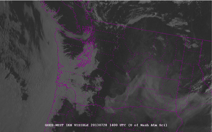
1-km visible satellite loop of Washington State, from 7am to 9pm local (PDT) on 28 July 2013. Counties are outlined in purple. Courtesy of the University of Washington - http://www.atmos.washington.edu/cgi-bin/list.cgi?vis1km. Click to enlarge.
The fire in the northeast corner of Kittitas County (center of the state) is evident from the eastward-moving smoke plume. Later in the afternoon, about 3pm (2200 UTC), you can start to see the series of whitish knobs forming on top of the fire. These are the pyrocumulus. They really start to explode around 5 to 6pm (0000-0200 UTC).
As an aside you can also see the fire in south central Washington, although there are not so many pronounced pyrocumulus clouds on the smoke plume.
There may have been a little bit of rain falling from the cloud, but a radar loop showed a stationary spot of reflectivity that was in the location of the fire. Fires are not always visible on radar, but sometimes they are large enough for the ash particles to reflect the radar beam and appear to be stationary “rain” showers.
I didn’t save a loop, but here’s a single image from Sunday night, showing the fire to my northeast.
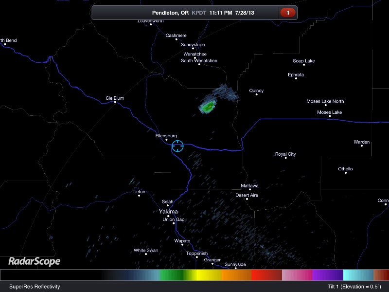
RadarScope image of the Pendleton, Oregon radar reflectivity. The blue circle shows my location, and the greenish blob to my northeast is the fire.
InciWeb (Incident Information System) has updated information and maps of the fire (and others) here: Colockum Tarps Fire. News articles today say nearly 70 square miles are up in flames and it is only 5% contained. The winds are fairly light now, but later in the week we could get a bit more wind and a slight chance for thunderstorms.
So far the fire has been mostly on grasslands, but if it spreads further west, it will become much harder to fight in the timberland. And if it spreads further south, it may start to threaten some homes and a wind farm.
Here’s hoping the firefighters get some better weather for fighting the fires, and everyone and their homes stay safe.
Permalink
07.10.13
Posted in Uncategorized at 6:29 pm by Rebekah
19 May 2013, the second moderate risk day in a row, this time for central to northeast Oklahoma up into eastern Kansas and western Missouri. The upper-level trough had now dug into the western Plains, a sharp dryline formed just west of I-35 in Oklahoma up into south central Kansas, and a few outflow boundaries from the storms in the area the previous day helped provide the focus for convective initiation.
We initially targeted somewhere from Medicine Lodge, Kansas to Blackwell or Ponca City, Oklahoma, and headed south from Haysville (south side of Wichita) just before noon.
Without a particularly strong cap, storms began to fire between 2 and 3pm, and we got on a tornado-warned supercell near Caldwell in south central Kansas.

We watched the supercell for a little while as it further organized and a large bowl-shaped funnel cloud began to lower.

As the storm began to catch up with us and the rain picked up, we attempted to get out ahead of it, but ran into some trouble.
In the now driving rain, I was all the more dependent on the guys for navigating and telling me where and when I should turn. A certain road just ahead was suggested, and I took it, not realizing until it was too late that it was a dirt road. Now in a loaded GMC Yukon on a clay road near the Kansas – Oklahoma border, once the rain starts, you’re almost certainly stuck.
I did my best, and I might have been okay if I had quickly see the gravel drive immediately on my left and tried to turn off there. However, about 20 or 30 feet down the road I began to fishtail, and while I was going slow and trying to slowly adjust, I was outmatched and the next thing I knew we were in the ditch.
Trying not to panic, I tried to straighten the wheels and have the four guys push the vehicle back on the road, but to no avail. The rain pounded down, the hail began, and we knew we were forced to wait it out and hope for the best.
As one of the guys looked at the radar and realized we were right in the path of the hail core, and then told us that at least one tornado had touched down on the storm and was also probably headed for us, I then did have a bit of a panic attack, mixed with anxiety at costing us a chance to see the tornado touchdown.
After what felt like hours, the hail and rain let up (and there was no tornado, thankfully), and a couple of the guys got out to take a look around. We were blessed to have missed the largest hail, though we still got golf balls that dented the roof of the Yukon (not a scratch on the windows, though).
Dean walked (barefoot! on one of the muddiest roads I had ever seen!) down to the main road, and a kind farmer saw our plight and stopped to help. The young man had a big sturdy rope that he hitched to the back of the Yukon and to the front of his truck, and then backed up down the little gravel turnout and with surprisingly little effort helped us out of the ditch and onto the gravel.
After we got back on the road (with a VERY dirty/muddy interior after we all tracked through that muck…took herculean efforts to clean it out later, and to clean our shoes), we decided to resume the chase, though by this time the storms were quickly squalling out.
By this point we had found out that south Wichita (close to where we had stayed the previous morning…yes, it happened again…) had seen at least one or two tornadoes, and there were also some decent tornadoes forming in central Oklahoma.
Somewhere just south of the Oklahoma border, we stopped to watch a storm for a little while, and to evaluate how the day had gone and how we wanted to proceed, as we were all still quite frazzled and frustrated.


As the show in our area was about over, we decided to have dinner in Ponca City. There we saw more footage of a large tornado that had gone through Shawnee, just east of Oklahoma City. I wasn’t exactly upset that we missed it, as it didn’t sound photogenic (became rain-wrapped soon) and was a destructive and killer tornado, but after a couple of somewhat disappointing days, there was a long talk at dinner about priorities and different chasing styles, etc., and the next day Dean and the two other Aussies decided to split off and Will and I chased together for the remainder of the trip.
It was a sad conclusion, but turned out quite well as we were able to get a much smaller car (Nissan Altima, a great little thing!) and enjoy a more relaxed style where we also saw the benefit of two photographers traveling together as we didn’t mind stopping now and then at interesting photo opportunities. We also ran into Dean and the Jons a few other times, which was fun to see each other under the meso again. I also took full advantage of having Will to myself to ask unlimited questions about New Zealand, where I would soon be moving to. 😉
Anyway, the five of us ended this day in Norman, Oklahoma, after about 12.5 hours and only about 250 miles.
Permalink
07.07.13
Posted in Uncategorized at 6:45 pm by Rebekah
18 May 2013, a moderate risk day for parts of the west central Plains. We had pretty good hope for this day, but a strong cap had us getting a little impatient and traveling further south than we should have, suckering us after the hope of a tail-end Charlie once storms started to explode and line out.
We didn’t leave Russell, Kansas until a little after noon, as we thought we were already in a pretty good target area (as it turned out, we should have stuck around even longer….the best show of the day was not 80 miles south of Russell, one of a few frustrating times this year where we missed the main event that happened very close to where we woke up in the morning).
We headed south to Medicine Lodge, thinking the moisture was better down there and that there might be a little better forcing near a sharpening dryline bulge. We also thought that once the cap did break, a squall line may form quickly enough to where we wanted to be towards the end.
After hanging out at a rest area just outside of town for a little while (and on the first toss one of the guys losing a frisbee into a tree), we moved further west to Coldwater, to be closer to the dryline and the surface low.
At this point storms had already started to fire further north, but we decided to check out a couple of cells forming near the Oklahoma Panhandle. Near the border, we saw a gustnado or two, but could tell the storms were already becoming quite outflow dominant.
We stopped for a while at a rest area at the border (along with perhaps a couple dozen other chase vehicles), realizing all we had now was a quickly developing squall line. There was some decent lightning and squall line structure though, so we snapped some photos and evaluated where we wanted to go for the night to set up for the next day.

Kansas-Oklahoma border squall line
Deciding upon somewhere around Wichita for the night, we retraced our steps back up to Medicine Lodge, and stopped for a minute at the rest area where we had lost the frisbee. Thinking that the winds from the squall line may have blown it out of the tree, we were hopeful, but ultimately disappointed that it only fell further into the tree (and it was one of the frisbees that is more like a ring, so easier to get stuck). 😛
We ate dinner at a Pizza Hut in Medicine Lodge, where we ran into Sean Casey (of the TIV and Discovery Channel fame) and a few other chasers, all wearing sad faces as we saw photos of several beautiful tornadoes that had occurred earlier near Rozell, on the storms further north.
It was a disappointing day, but I tried to cheer up my chase partners with thoughts of the fun we still had and what we might see the next day, which looked even more promising. We spent the night in Haysville, just south of Wichita.
We traveled this day for 11 hours, 30 minutes, and an estimated 370 miles.
Permalink
07.06.13
Posted in Uncategorized at 4:53 am by Rebekah
17 May 2013 shaped up to look like a possible day-before-three-weekend-days kind of event. A deep trough was just entering the western US, a surface low was forming around northeastern Wyoming, a warm front stretched through southern South Dakota, and a dryline through western Nebraska with dewpoints to the upper 50s gave us some hope of a marginal High Plains chase day.
We spent the previous night in North Platte, Nebraska, after having a down day driving up from Dallas/Fort Worth the day before.
We drove up Highway 83 that morning, and then down I-90 towards Rapid City, with the plan to play the triple point and follow storms down the warm front. I had never been to western South Dakota before, so I was quite excited by the prospect of seeing Rapid City and possibly going to the Badlands or Mount Rushmore if the day turned out a bust.
We made it as far as Wall (about 50 miles east of Rapid City), catching glimpses of the beautiful Badlands nearby, when convective initiation in western Nebraska forced us to turn around and go back the way we came.
Just across the Nebraska border, near Valentine, we stopped for a while to watch lightning under a little supercell.

After a few storms lined out a bit, we dropped further south in the hope of getting on a tail end Charlie.
Around sunset, just south of Hyannis, Nebraska, we saw two modest supercells which provided a nice scene amongst the sand hills and the colorful sky.
We stopped for a while to watch the storms, and the one nearest us soon became tornado-warned. We did not expect to see a tornado on it (and never saw more than a wall cloud), as it was so high based, but we ran into another group of Aussies and the lightning photographers had a field day as the supercell was quite a prolific producer. I didn’t bring my tripod on this trip (tried to pack light, but wished I had brought it!), so I just stood and enjoyed the show, and what a show it was!

Showing our position on the tornado-warned cell

Wall cloud under the supercell at sunset, and roll clouds in the foreground above my head.
Finally we had to drag our attention away and think about where to set up for the next day.
As we thought about targeting central to southern Kansas, we decided to push on to Hays, Kansas that night. Arriving in the wee hours of the morning, we found that all the hotels were booked as it was graduation weekend. Exhausted, we finally found a place to stay a little further on in Russell, at 4:30 am.
We traveled this day for 18 hours, 40 minutes, and an estimated 950 miles.
Permalink
07.03.13
Posted in Uncategorized at 6:23 pm by Rebekah
I can’t let the 15-year anniversary of my first tornado go by without posting something about storms!
I’ve had the rest of my chase photos from this year ready to post for a while, but have put it off for a couple of reasons–1) Yahoo! (my web host) changed the way they want us to upload files last fall, and I haven’t been able to figure out yet what I’m going to do about that…it might involve another (complete) reworking of the site, as I’m now sadly out of date, but will take some time to solve the problem. So no chase logs/photos/updates for now on the ol’ Green Sky Chaser page. I am working on this, however.
2) My chase vacation had some ups and some downs, and I have been trying to figure out how to deal emotionally with all that happened, before I could try to distance myself a bit and write more about it.
On the flight back to Kwaj, I wrote some of my conflicting thoughts down on my iPad. I was going to edit it for a future post, but I just decided I’ll go ahead and post it here raw and unedited, as it reflected my thoughts as they were fresh. I had just heard about the deaths of well-respected storm chasers Tim Samaras, Carl Young, and Paul Samaras, Tim’s son, as I sat in the Oklahoma City airport ready to board my flight.
Then soonish I will post chase logs from the rest of the trip, to the blog here, while in the meantime I keep beating my head against on the wall on what I am supposed to do with the main site.
——————————————————–
02 June 2013
These last three weeks of vacation for storm chasing have been a nice break, filled with good company, interesting forecasting challenges, and amazing storms, but have also brought great tragedy to many people. Here are some of my rambling thoughts on the subject.
As a storm chaser I sometimes find it difficult to reconcile feelings of excitement for witnessing beautiful and powerful storms with the destruction and heartache that can follow. Granbury, Shawnee, Newcastle, Moore, El Reno, Oklahoma City, etc. were hit hard during these three weeks, and even the storm chasing community lost three of its own most well-respected chasers.
Not long after the “chase-cation” began, we passed through Granbury, Texas, just after an EF4 tornado destroyed some neighborhoods and killed several people. The sight of leveled houses, sirens wailing, and crying people harkened back to when I helplessly watched a nearly 2-mile-wide EF5 tornado wipe out Greensburg, Kansas over 6 years prior, some memories which I had tried hard to suppress.
Greensburg was the first tornado damage I had ever seen firsthand, and it affected me so profoundly I nearly quit chasing, and only after I visited the town nearly a year later, and saw how well the community had come together to help rebuild, was I able to feel that I could start chasing again, but with a bit of an altered perspective that comes to many when seeing something like that.
I was startled to see Granbury like that, and again struggled with how I am supposed to feel and react. How quickly our joy at finally seeing a tornado and having our forecast verify can turn into horror at realizing what is happening or about to happen. No one ever wants anyone to get hurt or sustain property damage. And yet many storm chasers, myself included, chase for the beauty and awe of strong storms. We do what we can to report severe weather and help the warning process.
Everything came closer to home when Moore, Oklahoma was hit hard by another EF5 tornado. I did not see the tornado and avoided seeing the damage for as long as I could (however it is on the route to the Oklahoma City airport), as I wanted to remember the city as I had last seen it the morning of the tornado. I do not regret missing that tornado at all. I have many friends who live in the area and know some who lost all but their lives. Sadly others were not as fortunate.
I did see a multi-vortex tornado near El Reno 11 days later grow into a wedge as it crossed I40, when we finally lost it in the rain. Lives were again lost, including those of well-regarded storm chaser Tim Samaras (I remember first hearing of him and his “turtle” tornado probes in a National Geographic magazine years ago, after an intercept with the Manchester, South Dakota tornado in 2003), who has contributed quite a bit to tornado research and the chasing community; Tim’s 24-year-old son Paul; and Tim’s storm chasing partner also seen on The Discovery Channel’s “Storm Chasers” show, Carl Young. This is the first known incident of storm chasers being killed while actually chasing.
This news is still fresh and stunning to the chaser community, and I don’t yet know just what happened. I do know that the storm was a difficult and at times dangerous storm to chase, and many even experienced and safety-conscious chasers were caught up too close when the storm kept turning and there were a lot of people on the roads.
Mike Bettes of The Weather Channel was in a vehicle tossed a couple hundred yards and totaled, yet miraculously walked away with two others.
Many roads around and south of Oklahoma City were gridlocked as those scared after the recent Moore tornado panicked and heeded poor advice given by media outlets to drive south if they could not get underground. Some, myself included, got stuck in bumper to bumper traffic as violent winds and driving rain shook the car and large hail threatened and funnels came very close to us as we sat there.
We finally made it to Chickasha along with what seemed half of Oklahoma City during a mass evacuation. Hopefully the media will try to correct their statements and better educate people next time…it is much safer to plan ahead and go to shelter than to get stuck in gridlock and wait for the tornado to hit you in your car.
We all make mistakes, myself included, so I hate to point fingers or judge without knowing all the facts. I just know what I saw was utterly insane and I am amazed that more lives were not lost.
It will take time to process all that has happened on the break, and after seeing and hearing of so much pain it is tempting to try to desensitize myself to it all…after all, heartache occurs all the time and there’s nothing I can do to stop a tornado…but at the same time I don’t want to entirely shut myself off to it as I don’t want to forget those who lost so much…I find seeing these things firsthand it is harder to ignore the images than when watching them on a TV.
Those affected and all the damage are more than just statistics. They are seared on my memory and serve to remind me to respect the atmosphere’s power and make me want to assist however I can best, through reporting, donating, praying, etc. And then I get up the next day and do it all again, still drawn to the majestic beauty that awaits.
Permalink
« Previous entries Next Page » Next Page »
